


Picogorra - Tenteniguada
GENERAL DESCRIPTION. This trail runs from the island's summit (Pico de La Gorra) down to the moist Middle Mountain Region. It is a stretch of particular beauty, with contrasting landscapes that never fail to delight walkers.
The trail traverses two protected natural spaces: the Protected Landscape of Las Cumbres (High Mountain Region) and the Special Nature Reserve of Los Marteles.
Two large geomorphological formations, two calderas, stand out along the first stretches of our trail: the Calderilla Chica and the larger and deeper Caldera de Los Marteles. They both owe their peculiar morphology to their phreatomagmatic origin. The cold water of nearby ravines came into contact with the volcano's magmatic chamber, giving rise to violent explosive eruptions that eventually led to the colapse of the volcanic edifice, the two calderas being the result of this process.
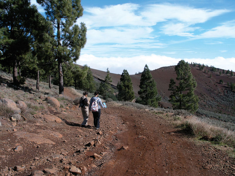
The Canarian pine trees (Pinus canariensis) we'll see along the first stretches of the trail are the product of the intense reforestation programmes undertaken by the Cabildo de Gran Canaria (the island's local government) since the 1950s. The undergrowth is made up of brooms (Teline microphylla), a rather colourful shrub in spring and summer.
The bottom of the Caldera de los Marteles -which was until recently farmed by the last farmers to live there- is an ideal spot where to stop for a rest.
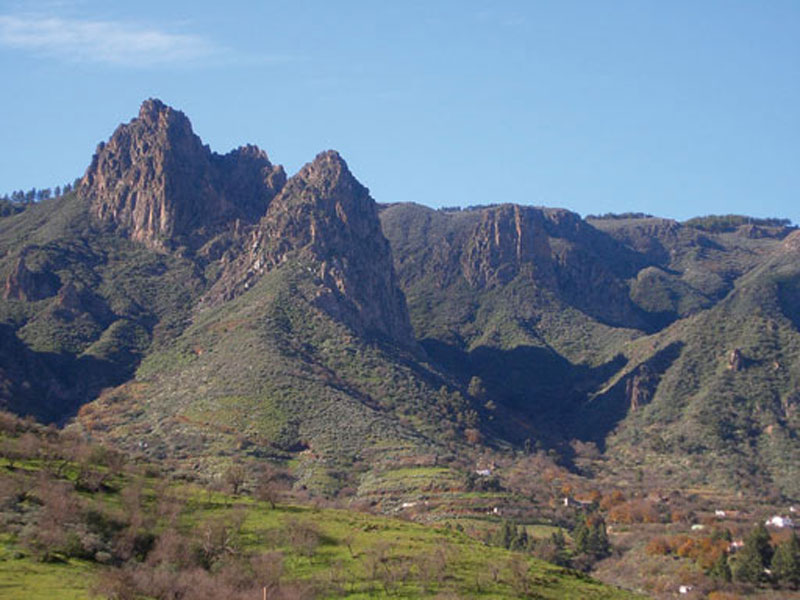
As we walk down the Caldera de Tenteniguada, which draws a wide semicircle open towards northeast, we'll enjoy spectacular views of Roque Grande, Roque del Pino and los Picachos, freestanding geological structures from the pliocene that have been modelled by erosion and which crown the moist valley of Tenteniguada, the southern border of the old laurel forest. The influence of trade winds, among other climatic factors, make this one of the rainiest areas on the island, with annual rates of over 1,000 mm. On the other hand, summers are very hot.
The abundance of farming terraces, perched practically everywhere on the steep walls of the caldera, has limited the natural vegetation to the upper parts of the walls and to the terraces that have been abandoned, which have been taken over by brooms, false brooms, flatpods and by the unmistakable Grand Canary borage (Echium callithyrsum).
This trail was for years the main means of communication between the High Mountain Region and Valsequillo. Shepherds and villagers used it to go to El Rincón and, especially, to Tenteniguada to buy goods, food and tools. The trail is of great ethnographic value, given the range of agricultural infrastructures that we'll find along it -threshing floors, animal enclosures, traditional dwelling, sheds and caves. The caves at El Salviar, where shepherds lived for many years -their descendents live at present in El Rincón-, are a good example of the degree of isolation that living far from rural nuclei involved. Some of the older neighbours in the area still remember the occasional funeral procession going down the mountainside below the Roque Grande on its way to the Valsequillo cemetery. Once they got to Tenteniguada they'd follow the path along the ravine bed all the way to the village and the cemetery.
Down the slope of the Caldera de Tenteniguada, towards the end of the last stretch of the trail, we'll come to the picturesque hamlet of El Rincón. This dispersed settlement displays an agricultural structure that is typical of the Middle Mountain Region of Gran Canaria, with house dwellings attached to farm fields. The combination of the quality of the water and the farmers' constant hard work produces outstanding vegetables and potatoes -so, if given the chance, we should not hesitate to buy some local produce.
Local cherries are renowned throughout the island, and during the first fortnight in July the Cherry Festival is held.
Jewellery making is one of the traditional crafts that is still going strong in Tenteniguada - El Rincón.
Likewise, local handmade goat cheese is worth trying, as well as the local goat cottage cheese tart. The trail goes from a height above sea level of 1,900 metre to 800 metres above sea level at Tenteniguada, so inevitably along many stretches slopes will be steep; the last stretch of trail especially should be approached with great care, with boots worn firmly for the path surface is made of lava gravel and it can be very slippery.

Trail Map
(Click on the map to enlarge it)
Trail Map
(Click on the map to enlarge it)
 Trail description
Stage 1: Pico de La Gorra - Calderilla Chica
 Our reference to get to the trail's starting point is the military base known as Los Pechos (The Breasts). To get there we should take the 18-3 Telde-Los Pechos road and, once there, take the road that leads to Pico de La Gorra. We can leave our car on the lay-by. We take a dirt track that sets off in a southeastern direction amidst pines (Pinus canariensis) and brooms (Teline microphyla).
After the first narrow curve to the right we'll come across a a path that runs towards the northwest -a landmark makes it is easy to identify it. We carry on along this path, walk across a small ravine and up a gentle slope, past some pine trees. In the distance we can already see the track that will take us to Calderilla Chica. We are walking on lava gravel. A few metres after some pyroclastic strata that have been dismantled by quarrying or erosive processes, we find a lava gravel quarry to the right of our path, towards the south-southeast (140º). About 600 metres into our walk, if we look towards the northeast, we'll enjoy a splendid view of the Calderilla Chica caldera.
Stage 2: La Calderilla Chica - Caldera de Los Marteles
 We carry on bordering the southern flank of La Calderilla along a narrow vegetation-free path, which slopes down first gently and then more steeply. It eventually brings us to a dirt track that we had already seen earlier on, boxed in down the bottom of a small ravine, and which we'll join at a crossroads where the track connecting Santa Lucía and La Calderilla is signposted. We take this track in a northern direction (355º) until we get to another crossroads where we'll find a tarmacked road and another dirt track with a chain across it. We continue along this dirt track, which goes past a group of traditional style houses with an unmistakable agricultural air to them, underlined by the infrastructures we can see near them, like sheds, a threshing floor and an animal enclosure.
We walk on ignoring all turnings -although it is worth leaving the track briefly by its narrowest curve to the right, to have a look, to the left of the trail, at the cave dwelling that still stands as a vestige of a traditional Canarian settlement.
A few metres on we'll find a narrow little path that runs across our track; we ignore it and carry on towards the west. As we approach the Caldera de Los Marteles we'll start to see wild olive trees (Olea europaea ssp. cerassiformis) and bitter spurges (Euphorbia obtusifolia), as well as a ravine that runs parallel to our track and which is the head of the Barranco de Guayadeque ravine. We walk past another group of houses on a shelf of the basin head -which has grown deeper- and we soon come to the Caldera de Los Marteles caldera. Once we get to the southern edge of the caldera we have two options: we can go down to the bottom -we can already see from above the abandoned farm fields-, or we can continue along our track until it brings us to the tarmacked road. We recommend going down, as we'll spare ourselves a few metres of tarmacked surface and we'll have the chance to enjoy a pleasant rest in lovely surroundings. To go down to the bottom of the caldera we take a turning that we'll see a few metres past the chain. Once at the bottom, we'll take a path that sets off right next to an almond tree (Prunus dulcis), and climbs up the northern wall of the caldera. The path is difficult to identify in some stretches, but it widens and runs clearly all the way up to the road after it has gone past a small construction near a group of century plants (Agave americana).
Stage 3: Caldera de Los Marteles - Era Blanca
The road goes from the northern end of the Caldera de Los Marteles down to El Rincón de Tenteniguada, but we walk across it and we'll find two paths. We take the most westerly path, which twists and turns down the side of the Barranco de La Umbría ravine.The other path, about 100 metres to the east, which goes down via Los Alfaques, is the path we'd take if following this guide book's trail number 20. The cliff wall in this area is extremely moist due to the horizontal precipitation caused by the sea of clouds, which is retained by the substratum and the vegetation.
We walk across the bed of the Barranco de La Umbría ravine, and walk up a gentle slope, leaving behind us some caves and pine trees. After a flat stretch of trail we'll find a narrow path to the right -there is a landmark- and we walk down it through shrubland made up of brooms, spurges and giant sow thistles (Sonchus acaulis).
We walk across a small ravine right below the Cuevas del Salviar caves, but we recommend not taking the path that runs up to them. After walking past some pine trees we carry on towards the north along a narrower but well-kept path with a stone wall that flanks it. From here on the trail offers excellent views of Tenteniguada, of the fertile lowlands of Valsequillo, as well as of northeastern coast of the island, from Telde to Las Palmas de Gran Canaria. This stage of the trail ends by a rocky monolith that cuts across the path. This area is known as Degollada de la Era Blanca.
Stage 4: Era Blanca - El Rincón
 A few metres further on we'll come to a crossroads where we'll take a small turning to the left, towards the northeast, that will bring us to a shelf on the slope, where the path reaches a pine grove that we had already seen earlier on standing parallel to it. We leave the pine grove to our left and carry on down the winding path with the large looming monoliths above us. At this point we'll start to come across very large Grand Canary borages (Echium callithyrsum).
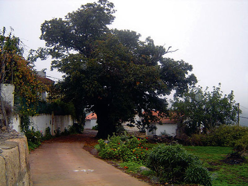
After walking across several tributaries of the Barranquillo de Quevedo ravine, we'll come to a flat stretch of trail where the surface is covered in lava gravel. We walk up for a few metres and then carry on again twisting and turning down the hillside of Lomo del Pleito as far as the first houses of the settlement of El Rincón. From now on we'll find farm houses and fields on both sides of the dirt and concrete tracks that we'll follow. When we get to a crossroads by a large hundred-year-old chestnut tree we take the turning to the right.
We carry on down El Roque street, towards El Rincón. As we walk down we'll once again enjoy a splendid view of the northeastern coast of Gran Canaria; it is also worth looking back and admire the Caldera de Taburiente and the escarpments we have walked down from. Once we get to El Rincón, we have the option of carrying on down to the centre of the village of Tenteniguada.
Cuevas del Salviar caves
A cave is a natural hollow in the terrain formed through a geological process involving the combination of chemical processes, tectonic forces and atmospheric factors. In Gran Canaria there are also many manmade caves.
Las Cuevas del Salviar caves were used by prehistoric Canarian aboriginals, and after the conquest they continued to be used and, in fact, were still inhabited as recently as the 1950s.
They are on a hillside, in an area between the High Mountain Region and the village of Tenteniguada, which was frequently traversed by shepherds and their flocks of sheep and goats. At present, despite their apparent state of neglect, there are some metal doors barring access to them.
Caldera de Los Marteles
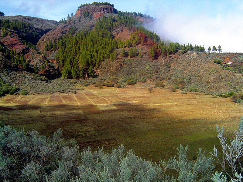
The Caldera de Los Marteles is one of the most peculiar geomorphological units on the island. Given the scarcity of recent volcanoes, it is a volcanic element that provides the Special Nature Reserve of Los Marteles with great scenic, ecological and scientific value, not to mention the spectacularity of the Caldera itself. It dates from the most recent eruptive cycle in the geological formation of the island, between 12,000 and 15,000 years ago. It forms part of a complex that includes La Calderilla and a few other cones located to the southeast of both calderas. Although of differing morphology, all these volcanic structures have a phreatomagmatic origin. In this kind of eruptions there is an interaction between magma and water -in this case coming from an aquifer. The explosiveness of the eruption itself, which was already quite powerful since it involved acid magma with a considerable degree of previous fragmentation, was intensified by the quick evaporation of water as it came into contact with the magma. The resulting explosion caused this great circular flat-bottomed depression, which has a diameter of about 550 metres and walls with an average height of about 80 metres. Though no longer used for farming, in the past cereals and forage plants were grown in it; it was also used for livestock raising, and was included in the itinerary of seasonally migrating livestock.