


Cruz de Tejeda - Tejeda
GENERAL DESCRIPTION. This trail runs through a landscape characterized by the abundance of brooms, false brooms and lavenders, as well as almond trees, a non-native but widespread species. Especially during the months of January, February and March, this northeastern area in the Caldera enjoys a rather colourful scenery. In fact, in February a rather popular festival takes place in Tejeda, the Festival of the Almond tree in Bloom.
Throughout the walk we'll be able to observe old volcanic dykes formed during the first cycle of the island's volcanic formation, which took place in the caldera over more than 12 million years ago. The magma reached the surface through faults or fissures, forming dykes. After the volcano's edifice had sunk back into the empty magma chamber, causing the formation of a large caldera, the magma rose again through a complex network of cone sheets, filling the caldera up again.
The village of Tejeda and the neighbouring hamlets of La Culata, El Rincón, Guardaya or La Solana occupy an area where debris slopes form an intermediate area between the escarpments of the caldera and the bottom of it, softening the relief and facilitating human settlement.
The dispersion and extreme fragmentation of farm fields and of property is a characteristic of all this rather abrupt area, and it is particularly noticeable along the last stretch of our trail.
Tejeda is the largest village in this area, and where the majority of commercial and tourist activity within the municipality takes place. Both its natural and cultural appeal draw an important number of visitors to the municipality.

Trail Map
(Click on the map to enlarge it)
Trail Profile
(Click on the map to enlarge it)
 Trail description
Cruz de Tejeda - Tejeda
 The path starts to the left, as we stand facing the Parador Nacional (State-owned Hotel) and the stone cross to which Cruz de Tejeda owes its name. We walk down it -with the north wall of the caldera, Risco Chapí, opposite us- twisting and turning amidst shrubland made up mostly of brooms, sages and giant sowthistles.
The view is impressive: Roque Bentayga, Roque Nublo, the pine forest of Pajonales, the massif of Güi-Güi, Mesa de Acusa, the massif ofAltavista, and even the village of Aldea de San Nicolás in the distance. If we look back and up we'll see the room-housing wing of the Parador Nacional hanging over the mountainside, ideally located not just for a restful stay, but also for the enjoyment of this vast scenery.
A few minutes further on we'll find a small knoll covered in brooms. If we look downhill we'll see some dykes that erosion has brought to the surface, and large rocks that have rolled down the slope and that now lie by an old shed.
Just before we come to the end of the first stage in our trail we come across a new plant species, the spurge (Euphorbia regisjubae). About 15 or 20 minutes after setting off from Cruz de Tejeda we'll arrive at a roundabout on a tarmacked road. We carry on along this road in the direction of Artenara. Past the 27th kilometre milestone, at a narrow curve to the left, we leave the tarmacked road on our right and take a path that starts by an old almond tree. The path runs downhill amidst brooms, spurges and some almond trees.
In the distance we can see the village of Tejeda and, further on, Roque Bentayga. When we get to a small electricity post we turn right; we'll see what might be thought of as a stone wall, but is actually a volcanic dyke. When we get to the road we turn right again and take another path that runs by another electricity post. After a few metres, and taking a north-west direction, we walk past a large whitish stone. The path now runs flanked by dry-stone walls of old abandoned farming terraces.
Further down the hill we can see El Rincón, whose traditional style houses are very well preserved. Once we get to a dirt track we should turn right; we'll get to a concrete path that will eventually take us to a nearby road. We carry on and will get to a roundabout where we'll find a sign that reads “Pueblo de Tejeda”. About 300 metres further on we'll get to a crossroads -Tejeda is only a kilometre away now, and we continue straight ahead in its direction, ignoring the turnings that lead to small settlements such as Las Crucitas, Erilla and Majuelo.
Medicinal Flora Museum of Gran Canaria
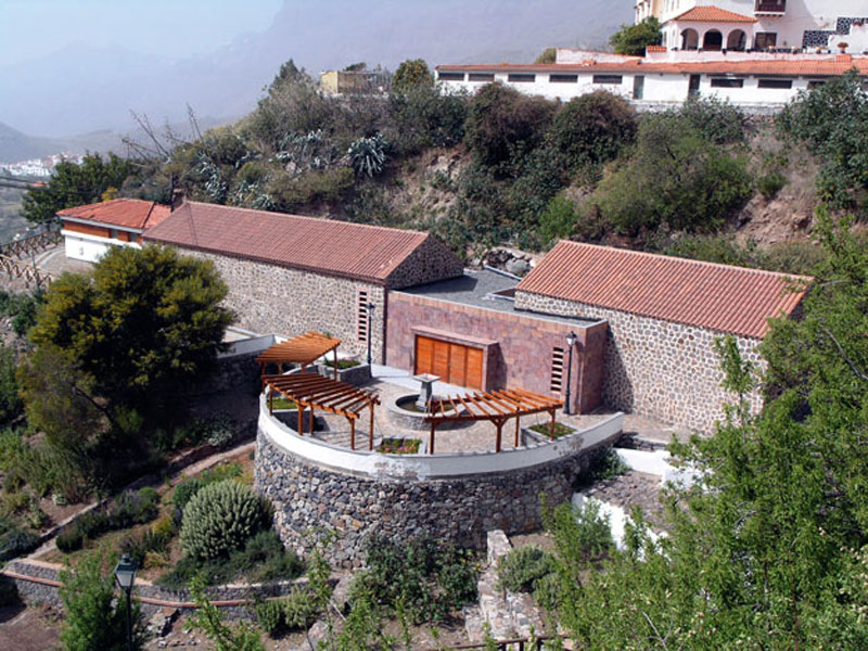
The aim of the Medicinal Flora Museum of Gran Canaria, located in the municipality of Tejeda, is to divulge, both rigorously and entertainingly, everything to do with the traditional use of local flora in Gran Canaria and, especially, in Tejeda.
Several prestigious institutions contributed to the setting up of the Museum, in collaboration with a multidisciplinary team formed by, among others, botanists, anthropologists, historians, geographers and engineers.
In one of the Museum's exhibition modules there is a display of a 19th century chemist's shop, on loan from the Museo Canario, that belonged to the Quevedo Codorniú family.
The Museum's function as an interpretation centre is divided into three units:
. Exhibition room: where a number of modules explain the different traditional uses of Gran Canaria's flora
. Multipurpose room: it includes a lab where demonstrations of extractions of colouring and aromatic essences take place, a herbarium, information point and small library. Workshops are occasionally held here.
. Interpretative garden: where visitors may see some of the most representative medicinal species arranged in flower beds according to their purging, aromatic and other properties.
Lavender lavandula minutolii)
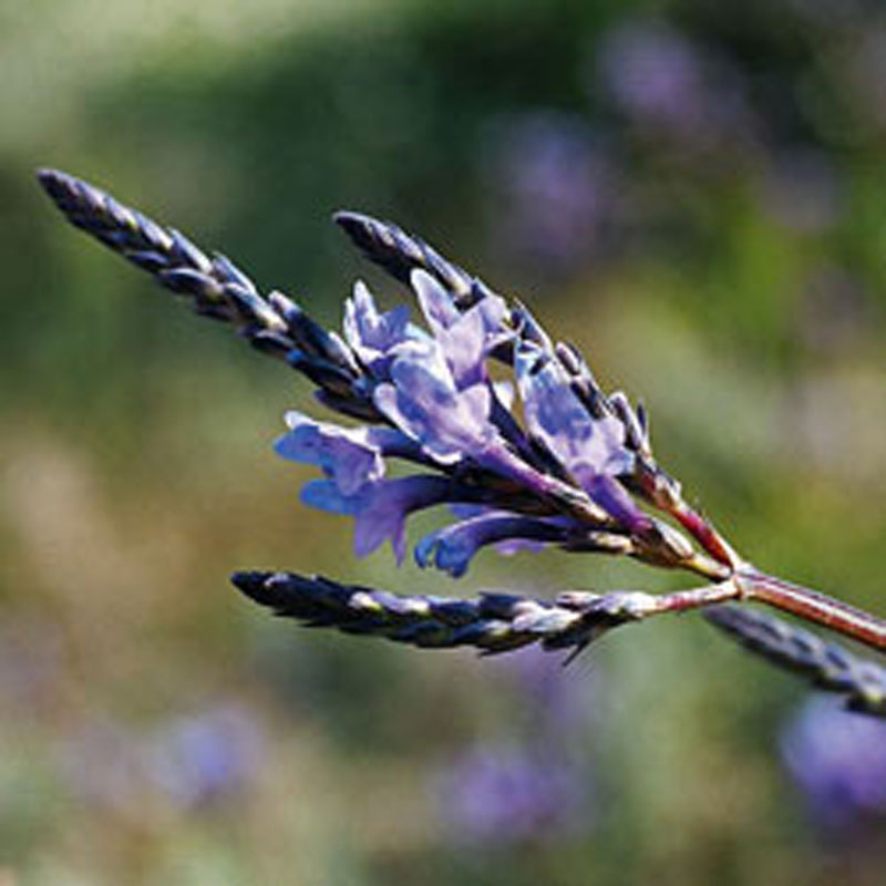
It grows widely throughout the central and southern areas of Gran Canaria, from the height above sea level where spurges grow to the pine forest and higher mountain region. It is a small shrub that can reach a height of 1.5 metres, with short dense clusters of blue or purplish flowers borne in whorls held on spikes above the foliage. It has slightly tometose leaves.
Its medical properties are used in the Canary Islands to treat different ailments. It is used in aromatherapy for its relaxing, soothing qualities, to fight sleeplessness. Mixing its leaves and flowers with olive oil an ointment is made that relaxes muscles, reduces tension and even relieves headaches.
It is also brewed to calm stomach aches, remove intestinal parasites, reduce a fever and soothe insect bites.