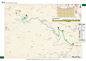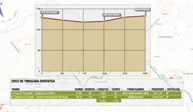
Cruz Timagada - Bentayga
GENERAL DESCRIPTION. Roque Bentayga is without doubt one of the most imposing sights in Gran Canaria, and it also marks the geographical birthplace of the island, since this is the site where the first shield volcano rose from the bottom of the sea to give rise to what became the foundation of the island.
One of the most interesting aspects of this emblematic outcrop is its historical and archeological importance. One of the most notable events to take place towards the end of the conquest of the island by the Spaniards took place on its summit, and there are several archeological sites of extraordinary interest in its surroundings.
Located at 1,404 metres above sea level, Roque Bentayga is a spectacular basaltic outcrop that was of special significance for the prehispanic inhabitants of the island. There was a cave settlement here made up of dwellings, silos to store surplus grain and burial niches. It also became a fortress where the ancient Canarians took refuge and resisted Spanish attacks. Above all, though, it was a sacred site of worship.
An almogarén was a site of worship -generally found at an elevated location- where Acorán, the god of the ancient Canarians, was invoked.
To the east of this formidable volcanic plug there is a square-shaped area that has been dug into the rock, with basins and grooves, which experts have interpreted as a site of worship. Nearby there are also sites with rupestral letter-shaped libyco-berber engravings, as well as caves that served as burial grounds. Many of these cavities still have the original dry-stone walls raised to seal them. If we walk up to the almogarén from the Interpretation Centre it is still possible to see a stone wall that runs along all of the eastern and southern side of the base of the rock, which experts believe served a defensive purpose during the last stages of the Spanish conquest, when the conquistador Pedro de Vera unsuccessfully laid siege to Bentejuí, a member of the royal family of the guanarteme -ancient Canarian king- Tenesor Semidán, and his likely heir.
Further towards the west, there is the settlement known as Cuevas del Rey. It is made up of manmade caves dug into the tuff that were used as dwellings and silos. To get to this settlement we have to walk down the road from the Interpretation Centre and take the first turning towards El Chorrillo, which links Roque Bentayga with Cuevas del Rey.
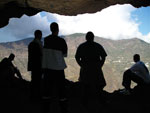
The caves vary in shape, some of them having a remarkable cruciform floorplan. The most notable among them is the one known as Cueva del Guayre (Guayre was the title of the local lord); it is a large square-shaped elaborately dug-in cave whose interior has been painted in white, black and red. On the floor there is a complex network of basins and grooves, and on a higher level there is a substantial silo of rather difficult access where the settlement's surplus grain was stored.
 Trail description
Stage 1: Cruz de Timagada - Casas de La Umbría
The trail starts at Cruz de Timagada, and runs initially in a northwestern direction towards Cuevas del Huerto. The path begins between two dry-stone walls; we walk up and over a hillock, amidst brooms, bitter spurges and buglosses.
We go on walking uphill and enjoying the spectacular views: to our right the village of Tejeda, Riscos de Chapí and the cave-dwelling village of Artenara; to our left, in the distance, the greenhouse plantations in La Aldea de San Nicolás, flanked by the massifs of Güigüi and Inagua, which border the huge basin. The volcanic material in this area is more acid, they are mainly phonolites and trachyphonolites.
We walk down with Roque Bentayga right opposite us. We then start a light ascent up Lomo de Las Moradas, easily identifiable by the reddish colour of the rock. There is a colony of cardoons (Cynara cardunculus) in this area, a species much favoured by cheesemakers in the north of the island, who use it to flavour their popular queso de flor, or “flower cheese”. A common bird found in this area as well is the red-legged partridge (Alectoris rufa), a species that only in Gran Canaria is still found in the wild.
We go down a narrow path flanked by several almond trees as far as a covered water deposit that we'll find next to a dirt track. Here we turn towards the south and shortly afterwards turn right towards the northwest, and walk on until we find a tarmacked road.
We follow this road towards the north-northwest, remembering to walk on the left-hand side of the road. After about a kilometre and a half we'll arrive at the junction that will take us to Roque Bentayga.
Stage 2: Casas de la Umbría - Roque Bentayga
At this junction, before we continue on our way towards Roque Bentayga, opposite a large stable housing goats and sheep, we'll find a cheesemaker's shop, where, apart from a range of fresh, semi-cured and cured cheeses, we can also buy vegetables, fruit and local wine. Among the cured cheeses the most popular ones are those rubbed with oil and gofio or paprika.
A tarmacked, sinuous road, about two kilometres long, will take us to the base of Roque Bentayga. On the way there we'll go past a turning to the right that leads to La Higuerilla, La Solana and El Chorrillo and, shortly afterwards, another turning to the left that leads to El Espinillo. Once we arrive at the base of the monolith we'll find the Interpretation Centre, designed to divulge the prehispanic culture associated with Roque Bentayga.
It takes about ten minutes up a somewhat steep slope to get from the Interpretation Centre to the actual base of Roque Bentayga and to the archeological site. From its summit we'll be able to see the defensive wall raised by the prehispanic Canarians, the almogarén and some interesting caves.
Bentejuí
Bentejuí was one of the most renowned prehispanic leaders during the last stages of the conquest of the island by the Spaniards. He led the last faction of Canarians who refused to submit to the military might of the Spaniards and chose the path of resistance to the bitter end.
Three years after the Spaniards had undertaken the conquest of the island, the king or guanarteme of the native inhabitants of the island, Tenesor Semidán, agreed to travel to the Spanish mainland and seal an agreement with Fernando, King of Aragon. Tenesor Semidán became a christian, adopting the name of Fernando Guanarteme, and Tamarán, now called Gran Canaria, was incorporated to the Crown of Castile. In exchange, the freedom of the Canarians and their social and political structures would be respected.
During Tenesor Semidán's absence from the island, Bentejuí, with the support of Telde's Faycan (local lord), whose revealing name was Tazarte, meaning “rebellion or dignity” led the resistance to the Spaniards.
On Tenesor Semidán's return, the Tagoror or ruling council met and eventually ratified Tenesor Semidan's agreement with the Catholic Monarchs, Isabel I of Castile and Fernando II of Aragon. Bentejuí, however, refused to submit, and together with his ally the Faycán of Telde continued to fight the Spaniards.
It was at Roque Bentayga that Pedro de Vera unsuccessfully laid siege to Bentejuí and his followers. According to the historian Viera y Clavijo, when Tenesor Semidán made an attempt to persuade the resistants to surrender, the Faycán of Telde defiantly refused saying: “Tamarán has not disappeared yet; here you have us all, on these hills”.
After the unsuccessful siege, Bentejuí and his followers set off towards the west, seeking refuge in an area that has not yet been identified. It was there that the final surrender took place, although both Bentejuí and the Faycán of Telde chose death rather than surrender and leapt off a cliff.
Cardoon
Cardo cardunculus (var. ferocissima Lowe) is a species native to the islands. It is a plant 25-125 cm tall, with thorny tomentose leaves. The flowers are blue or purple, occasionally whitish, and are collected in capitula on a fleshy receptacle. The pappous fruit is hairless, glossy with brown spots, and 6-8 mm in size.
It is known as “wild artichoke”. It is edible, and its aquenios are used as pigeon and poultry feed. It has medicinal uses: its flowers have emollient properties, and its roots are boiled to produce a diuretic and antinephritic brew. The juice of its leaves and stem is used in the curdling process of some local cheese varieties.


