


Artenara - Cruz de Tejeda
GENERAL DESCRIPTION. This itinerary borders the northern edge of the caldera and connects two municipalities, Tejeda and Artenara. The trail starts in Artenara, continues along Riscos de Chapí -opposite Roque Bentayga- through the pine forest of Cueva Caballero and comes to an end at Cruz de Tejeda.
The trail covers a space that runs parallel to the structural geological axis of the island of Gran Canaria (see geological map of Gran Canaria), where ancient miocenic material (between 5 and 14 million years old) formed by salic lava flows and pyroclasts (especially trachites and phonolites), comes into contact with more recent material, such as lava flows, Pre and Roque Nublo agglomerates as well as basaltic pyroclasts. In the case of the latter, they date from between 5 million and a few thousand years ago, in other words, they cover the middle volcanic cycle in its totality and part of the recent volcanic phase.
There is a striking number of caves in this area, which are the result of the effects of erosion on the rock's softest elements (tafoni). Many of these caves were inhabited by prehispanic Canarians, and by shepherds and farmers as well after the conquest, and many of them are still used as homes even today by the local population.
The weather in this area is typical of the weather on the higher mountain areas of the Canary Islands, in other words, there is a marked oscillation between cold winters and hot summers, with temperatures ranging between 0ºC in January and December and over 35ºC in August. Rainfall is scarce, and very occasionally it snows. Wind blows regularly and with force for a good part of the year, and, unlike the northeasterly trade winds, it tends to blow from the northwest.
"In contrast with this wonderful land, the higher region of this island is desolate and arid, no grass or shrub grows there, except for the above mentioned broom; for it is so high above the clouds that it receives neither dew nor rain, but is exposed to a fine, dry burning wind that generally blows from the west, unlike the trade winds that blow below, under the clouds: during the night this westerly wind blows hard, but it abates during the day. In winter the summit of the island is inaccessible, for it is covered in snow". (1)
These climatic conditions favour the presence of mountain shrubs -brooms, false brooms and flatpods, and of leguminous and xerophile plants like thymes and sages, among others. There is an important presence of conifers in this area, the result of the reforestation programmes undertaken by ICONA (Instituto Nacional para la Conservación de la Naturaleza -the National Institute for Nature Conservation) from the 1950s onward, although there are some natural pine tree specimens as well.
The trail goes through an area included in the Parque Rural del Nublo (Nublo Rural Park). This natural space amounts to 17% of the protected natural territory in Gran Canaria. It was initially declared a Nature Park (Parque Natural de la Cuenca de Tejeda) in 1987. It is currently the largest Rural Park in the Canary Islands, and part of it is included in the area recently declared World Biosphere Reserve(2).
The municipality of Artenara has a surface area of 66.70 km2, and it is located, together with Tejeda, at the summit of the island of Gran Canaria. It is about 50 Km away from the city of Las Palmas de Gran Canaria, and it is reached via the road known as the Carretera del Centro (Central Road), which runs through Santa Brígida and Vega de San Mateo (GC-325), Las Lagunetas and Tejeda (GC-15), from where the GC-21 takes us straight to the village of Artenara. Another option is to take the first turning right the after Las Lagunetas, which will also take us to the trail's starting point in Artenara. A third access is via Guía or Gáldar, along the GC-220.
It is the highest municipality and village on Gran Canaria, it's average altitude is 1,270 metres above sea level. According to the 2006 census it has 1,306 inhabitants. Over the last few years the municipality has undergone a process of revitalization thanks to the development of rural tourism and new services associated to it. Artenara is known for its pottery (especially at Lugarejos) and its woven products.
Regarding traditional festivals, the main one is held in honour of the Virgen de la Cuevita (the Virgin of the Little Cave). It takes place in August, and a large number of visitors come from all over the island for the occasion.
(1) GLAS, G. (1982): Descripción de las Islas Canarias (Description of the Canary Islands). 1764. Translated by Constantino Aznar. Instituto de Estudios Canarios. Tenerife; p. 65
(2) The World Biosphere Reserve of Gran Canaria was declared by UNESCO on 29th June, 2005.

Trail Map
(Click on the map to enlarge it)
Trail Profile
(Click on the map to enlarge it)
 Trail description
Artenara - Cruz de Tejeda
"From Tejeda till here (Artenara) the path is dangerous, as it travels along a slope filled with holes and cliffs. The area is most peculiar. In the middle of a great mountain it is possible to see some holes, like birds' nests. They turn out to be a large number of caves in a row, some concave like domes, others with a flat ceiling (...)" (3)
The current state of the trail is very different from our historian's description, as both danger and difficulty are considerably less nowadays. This is a very recommendable itinerary, as the views it offers the hiker are stunning. It starts at the church of San Matías, in the village of Artenara. The church is of relatively recent construction: it was initially built at the end of the 19th century, and between the 1950s and 1990 it underwent extensive reforms. The current church was built on a site formerly occupied by an old chapel built in the 17th century dedicated to the Virgin of the Rosary and dependent on the Parish of Gáldar. There are hardly any vestiges of it left.
(3) VIERA Y CLAVIJO, J. de (1982): Noticias de la Historia General de Las Islas Canarias, tomo 2, Ediciones Goya. SantaCruz de Tenerife; p. 395.
Stage 1: Artenara - top part of Guardaya
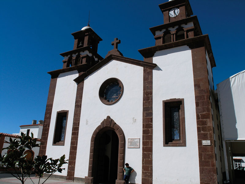 This itinerary starts at the church of San Matías. From there we cross the street and walk up the steep slope flanked by the former post office (nowadays a bar) and the local police station. This will take us to the chapel of the Virgen de la Cuevita (Virgin of the Little Cave).
Before reaching the chapel we'll go past the village's public baths and the chemist shop. Immediately past the latter we'll see a sign indicating that the chapel is 250 metres away, by which point the slope will have eased off. From here on the Caldera of Tejeda with its main geological features becomes visible: Roque Nublo, Roque Bentayga, Cuevas del Rey, El Roque and El Roquito, Mesa de Acusa and Los Pechos.
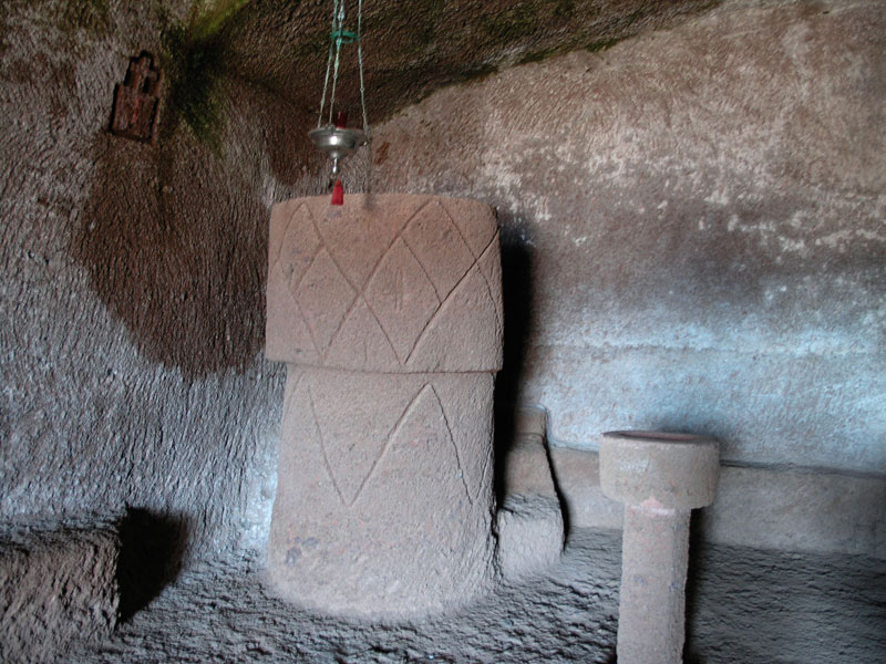
The village quarter we go through to reach the chapel is called La Asomada. It will take us five minutes to arrive at the chapel of the Virgen de la Cuevita, which is a peculiar building worth paying a visit to. The chapel, about 400 metres away from the parish church, has been dug into the rock (Roque Nublo volcanic agglomerate). The chapel dates from the 18th century. It was extended over a ten year period starting in 1858, and in 1990 it was once again reformed with the addition of the altar, baptismal font and the priest's celebrant chair, all of them carved from the rock (4).
To continue the trail we go up some steps we'll find to the left of the chapel. They are rather steep. Once we get to a crossroads we'll find some half cave-half manmade buildings opposite us. We'll go on walking to the right hand side of these edifications, in other words, towards the south east. A narrow iron pipe runs parallel to the trail.
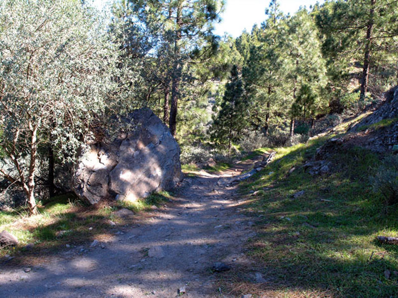
At the next crossroads we'll turn right, following the direction indicated by the stone marker we'll see on the ground. About thirty minutes into the walk we'll come to a cobbled curve that will lead us to a forest track, which we will now follow. Once again we'll come to a curve where there is a large stone with a white arrow drawn on it. There we leave the forest track and walk up a path that runs along a dry stone wall and pine trees.
There are also brooms and spurges (Euphorbia canariensis) to be seen along this path. After about five minutes we rejoin the forest track. At the next crossroads we ignore the turning to the right, which goes towards Cuevas del Candil (5)), and we continue to ascend along the same path towards the southeast. In this area the vegetation changes and we are gradually surrounded by sages, thymes, asphodels, buglosses and, of course, the pine forest. The trail at this point becomes rather sinuous, curve following curve. If we leave it and get to the edge of the Caldera de Tejeda, we'll be able to see the hamlet of Guardaya down at our feet, and further out into the distance the greenhouses in La Aldera de San Nicolás. If the day is clear, we'll also be able to see the islands of Tenerife and La Gomera. It will have taken us about an hour to come to this point, and this is where our trail's first stage ends.
(4) LUJÁN HENRÍQUEZ, J. A.(1994): Aspectos históricos de Artenara. Excmo. Cabildo de Gran Canaria e Ilmo. Ayuntamiento de Artenara. Las Palmas de Gran Canaria.
(5) Cuevas del Candil are located on Montaña de Artenara; the importance of these caves derives from the rupestral engravings their walls are decorated with, triangular forms which are supposed to represent fertility-related female vulvae.
Stage 2: Top part of Guardaya - Cuevas del Pinar in Cueva Caballero
Returning to our path, Juncalillo and, in the background, Sardina de Gáldar, can be seen right behind Montaña de Amagro. Towards the south east we can see the foothills of Montañón Negro and opposite us, in the same direction we are walking, the area of Los Moriscos. The pine forest dominates this natural space. The slope now eases off and soon we end our ascent and start our descent towards Cuevas de Caballero (an archeological site consisting in caves with rupestral engravings). By this time we will have been walking for almost two hours, a bit over half of this itinerary. This would be an ideal spot where to have a rest and a snack, right above the Riscos de Chapí, enjoying the views over the Caldera de Tejeda.
Stage 3: Cuevas de Caballero - Degollada de Las Palomas
Once we leave Cuevas de Caballero, we continue up the forest track bypassing the area of Los Moriscos. At this point we move away from the edge of the Caldera, taking a detour. The slope becomes slightly steeper now and when there is a clearing in the pine forest we can once again see the north side of Gran Canaria, with Tenerife in the background. Further on along the trail we'll come to a stone cross erected in 1913 and dedicated to Christ the Redeemer.
Volcanic gravel now covers the trail, which now begins a gradual descent towards the Degollada de Las Palomas. Apart from the pine trees we now come across chestnut trees and, in the shrubland, ferns. When we get to the first crossroads we turn right, walking under the cables of a nearby electricity pylon The track narrows at this point, becoming a rather steep path, which along this stretch of trail is crossed by many dykes belonging to the Tejeda cone sheet. Stage 3 of our trail ends at the scenic viewpoint of Degollada de Las Palomas, by a signpost that informs us that we now find ourselves within the Protected Landscape of Las Cumbres.
Stage 4: Degollada de Las Palomas - Cruz de Tejeda
 We now join road GC-21 in the direction of Cruz de Tejeda. We walk along the right-hand side and very soon we'll come across a signpost announcing the Nublo Rural Park. Next to it there is a cobbled path into which we turn. This path runs along the edge of the Caldera. Opposite us we'll see a mountain peak with some radio aerials; to the left of the path there are some white buildings and, to the right, we have the Caldera de Tejeda with Roque Nublo and Roque Bentayga, two freestanding volcanic plugs.
By now we will have been walking for two and three quarter hours, and we will be only fifteen minutes away from the end of the walk. This final stretch will take us past an ochre deposit towards a water tank located near the Parador Nacional de Tejeda (Tejeda's State Inn). At certain points the path has crumbled away recently, but there is no danger involved in following it. Shortly before arriving at the water deposit the slope becomes rather steep, so we should take the necessary precautions when descending. Very soon we'll arrive at the parking area behind the Parador, where this trail between Artenara and Cruz de Tejeda comes to an end.
Rupestral paintings and engravings.
According to the Guide to the Archeological Heritage in Gran Canaria, “the majority of rupestral paintings are to be found in manmade caves dug into the tuff (volcanic rock). A range of colours, usually red, black or white were applied in different areas of the cavity representing different motifs. The most important example is the Cueva Pintada de Gáldar (Painted Cave in Gáldar), but there are others. Red skirtings, cave entrances painted in white, cave walls on which a base coat has been applied on which in turn circular motifs have been drawn, are some of the cave decorations that have been documented. This artwork possessed in all likelihood a symbolic character beyond its decorative purpose, but so far there is no certainty as to its nature.
Rupestral engravings have been recorded at several spots on the island, although there seems to be a greater concentration of them towards the south east. Among their different motifs there are anthropomorphic figures -occasionally sexuated- as well as zoomorphic figures. Lybico-berber letter-like inscriptions are also frequent, and triangular engravings identified as pubic representations".
Berthelot's Pipit (Anthus berthelotii)
The only pipit in the world to nest in the Canary Islands (and Madeira and the Salvage Islands) is the Berthelot's Pipit, known locally as bisbita caminero, chilín, chirringo or correcaminos (roadrunner). It is a common bird found on all the islands.
It is rather stylized in shape, with a length of about 14.5 cm, greyish upper parts and whitish lower parts, with a dark mottled breast. It lays eggs two or three times a year and feeds mostly on insects, larvae and small invertebrates that it hunts on the ground. It is a sedentary bird that tends to walk or run along the ground and is rarely seen perched up on a tree. It is fairly easy to see it in all kinds of relatively open habitats, wagging its tail.