


Caldera de Bandama
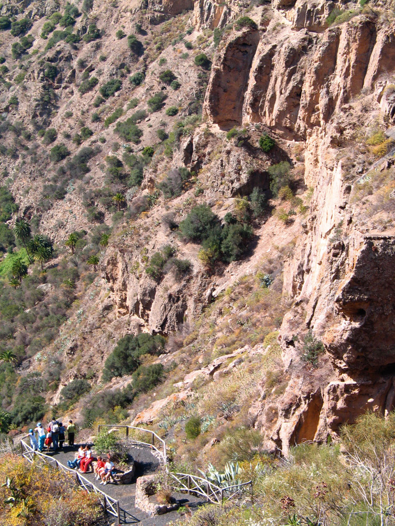
GENERAL DESCRIPTION. It is an explosion caldera that has a depth of over 220 metres. The diameter of the top edge -made up of Roque Nublo agglomerate- of its abrupt phonolitic rock walls is of about 1,000 metres, and its perimeter is over 3 kilometres long. The Bandama Peak (574 metres above sea level) and Caldera complex is of enormous scientific value. The government of the Canary Islands has included it in the extensive network of Protected Natural Spaces with the category of Natural Monument. Likewise, the Instituto Tecnológico Geominero de España (Spain's Geo-mining Technological Institute) declared it a spot of geological interest.
These volcanic structures were formed during what is known as the III volcanic cycle, also called the Post-Roque Nublo cycle; in other words, they belong to a relatively recent period in the long volcanological history of Gran Canaria, a period that goes from 2.9 million years ago to the present day. This phreatomagmatic eruption, whose origin lay in the Earth's mantle, surfaced via a large NNW to SSE 2-kilometre long crack, through which lava was initially spouted. This molten material gradually accummulated on two spots and this gave rise to two cinder cones. Finally, due to the interaction between magma and some aquifer's water that lay in the way of the magma's ascent through the southern peak's opening, the violence of the eruptions increased to the point that the volcanic edifice eventually subsided, with the result that a large crater was formed.
The eruptions over, all this area was occupied by a thermophilic forest, though other species that would provide a transition to the monteverde (the moist forest made up of laurel species and myrica-erica shrub forest) grew on the shady mountainsides and near the ravine beds. Up until the Spanish conquest, this ecosystem displayed great density, and was formed by different tree species that generally grouped forming monospecific forests, as the place names of several villages and areas in the surroundings of the Bandama complex reveal: El Sabinal (junipers), El Dragonal (dragon trees) or El Mocanal (mocan trees), among others. At present, a relict thermophilic forest survives in the interior of the Caldera of Bandama, concentrating mostly on its western side.
On the northern wall of the caldera there is an archeological site of great importance, the Cueva de los Canarios (The Canarians' Cave), a complex of cave dwellings and collective granary where there are libyco-berber letter-like inscriptions.
 The name Bandama does not have a prehispanic origin, but derives from a rich Flemish trader called Daniel Van Damme who settled in this area in the 16th century. He planted vineyards on the crater's bottom and sides in order to produce wine. The wines produced in this region of Monte Lentiscal, which includes Bandama, have acquired great prestige over the years, even outside the island. The first historical reference to growing vineyards and wine-making dates from Van Damme's own testamente, where he states: "I have planted vineyards in the caldera, which costs 2,000 ducats a year. Malvasia grows well and I should buy more vines and plant them well (...) because malvasia has great potential given the fertility shown by the bunches of grapes, and climate conditions seem to have little adverse effects on it, so I should replace other vines and plant more malvasia. It will be necessary to build a winery down there." (Torres Santana, 1991).
Daniel Van Damme did indeed build one of the oldest wine presses on the island in this extraordinary caldera, and it still stands there, although in a derelict state.
The name Bandama does not have a prehispanic origin, but derives from a rich Flemish trader called Daniel Van Damme who settled in this area in the 16th century. He planted vineyards on the crater's bottom and sides in order to produce wine. The wines produced in this region of Monte Lentiscal, which includes Bandama, have acquired great prestige over the years, even outside the island. The first historical reference to growing vineyards and wine-making dates from Van Damme's own testamente, where he states: "I have planted vineyards in the caldera, which costs 2,000 ducats a year. Malvasia grows well and I should buy more vines and plant them well (...) because malvasia has great potential given the fertility shown by the bunches of grapes, and climate conditions seem to have little adverse effects on it, so I should replace other vines and plant more malvasia. It will be necessary to build a winery down there." (Torres Santana, 1991).
Daniel Van Damme did indeed build one of the oldest wine presses on the island in this extraordinary caldera, and it still stands there, although in a derelict state.
Access to the caldera is along an old path that twists and turns down to the bottom. The path is steep and somewhat difficult to follow (in both directions), but reaching the heart of this intimidating volcano is definitely worth the effort. At the bottom of the caldera we'll find what was once a farm house, which is still inhabited.

Trial Map
(Click on the map to enlarge)
Trial Profile
(Click on the map to enlarge)
 Trail description
 To get to the starting point of our walk we need to take road GC-802 as far as Caserío de Bandama, a group of houses -some very old and beautiful- located on the northeastern edge of the caldera.
We'll find this little hamlet by a crossroads; the turning to the left leads to the summit of Pico de Bandama (Bandama Peak), which is a visit we recommend should be done first. The turning to the right leads to the Golf Club and to the village of La Atalaya. Our starting point is a few metres into this turning to the right. Between a bus stop and a restaurant we walk into this group of houses and after about 20 metres we'll come across a black gate beyond which lies the path that will take us down to the bottom of the caldera.
The path is easy to follow, as there are no turnings to disorient us. A few metres away from the starting point there is an excellent scenic viewpoint where we could stop. From there we'll be able to observe the great taluses that slope off the walls of the caldera. There is also an information panel with a detailed description of the space we are about to visit.
As we walk down -always on a surface of lava gravel- we'll be able to observe different samples of native flora, such as the Echium decaisnei (an indigenous bugloss), the Canary Woodworm (Artemisia canariensis), the Tree Bindweeed (Convolvulus floridus), the Canary Island Ginseng or Orobal (Withania aristata) -an indigenous variety of wintercherry- or the salmon-red shrub mallow (Lavatera phoenicea), as well as other rupestral species growing on rocks that occasionally line our path.
It takes us 30 minutes to get to the bottom of the caldera, where we'll find another -unmissable- path that runs around it. At its southern end there is a hide for birdwatchers, as there is a varied and interesting bird population within the caldera, especially Western Canary kestrels, long-eared owls, grey wagtails, blackcaps, canaries and goldfinches.
 Roughly in the centre of the caldera there is an old house -still inhabited-, the wine press mentioned above and a threshing floor, a relic of former times when cereals were grown here. There are also some crop fields, chickens, a donkey and some lush trees, that add a picturesque touch to the area.
The return is along the same path we came down on, although the fact that we are now walking uphill demands a bit more of an effort and takes a bit longer, about 45 minutes. In any case, as we have already said, the trail is worth it.
The lentisc (Pistacia lentiscus L.)
The lentisc is a deciduous and resinous shrub that belongs to the cashew family (anacardiaceae). It is a dense, ramified plant that can reach a height of up to 8 metres.
Its compound leaves are dark green in colour, and it has unisexual flowers borne in axillary spike-like clusters; its fruit is small and globous, red at the beginning and later black. It tends to grow in warm areas, adapting well to arid dry soils. It is a thermophilic species that grows successfully throughout the Mediterranean area and the Canary Islands. On occasions it forms large masses, both as the dominant species or mixed with other woody species of similar characteristics. It is often associated with wild olive trees, junipers and rosemary.
Its wood has frequently been used for turnery and in the manufacturing of small objects. All of the plant's green parts secrete a powerful aromatic odor, the result of a resinous juice that Asians especially seem to find very pleasant when chewing; it has been used to keep teeth looking white, strengthen gums and freshen up people's breath. The stem's resinous sap has even been used to varnish paintings.
Wine growing in Monte Lentiscal
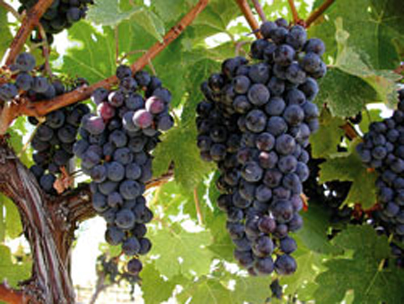
The wine growing area of Monte Lentiscal has a recorded surface area of 77.693 hectares, according to the Gran Canaria Designation of Origin Regulatory Council. The wine growing surface area is shared among 44 owners and/or leaseholders.
Different grapevine varieties have traditionally been grown. In most cases white and black grape vines are planted alternatively.
Grapevines were traditionally grown on stakes, or applying the old goblet vine training method, and these cultural practices managed to produce good quality wines. New plantations are mostly on espaliers, though, and they have adopted modern techniques that have successfully increased both productivity and the quality of the production.
Monte Lentiscal has been for centuries at the heart of wine -mostly red wine- production on the island. The Canarian wine market is focused on young wines, in other words, those that are not subject to the process of aging and are generally consumed within a year of their production.
Another of the peculiar characteristics of the vineyards found in Monte Lentiscal is the quality of irrigation farming in the case of the new vineyards. This is an area of scarce rainfalls, which are additionally limited to only two seasons a year. The special structure of the volcanic soil -lapilli or lava gravel- which is highly higroscopic and has very low evapotranspiration rates, allows for the high rate of night time humidity (typical of this area during precisely those periods when the vineyards need it most) to be retained. However, there are years when rainfall rates are particularly low, and there can be stretches of up to six months with no rain, which inevitably leads to the death of some plants. This is reflected in some of the bald patches or flaws that can be observed in some plantations. To overcome this problem farmers have resorted to installing irrigation systems, which have brought with them greater production stability and quality.