


Las Meleguinas - Jardín Canario
GENERAL DESCRIPTION. This itinerary starts in the municipality of Villa de Santa Brígida and it ends in the municipality of Las Palmas de Gran Canaria, running along the middle stretch of the Barranco de Guiniguada ravine, from the Puente de Las Meleguinas bridge to the Jardín Canario, the Botanical Garden.
The trail runs through a very beautiful environment with certain peculiarities in terms of both human and physical geography. The landscape is essentially agricultural in character, with extensive farmlands that spread out over a flat valley bottom. The stretch of ravine that lies between the Puente de Las Meleguinas and Puente de La Angostura bridges is a particularly wide stretch of the bed of the ravine, which was given its shape when the lava that flowed out of the La Caldereta de San Mateo volcano formed a delta where the three ravines that meet here -Merdejo, Alonso and Santa Brígida ravines- left alluvial deposits that accumulated over time. Together with the borrowed soil brought here in the past for the purpose of farming, they gave this area the rural character it currently exhibits.
During the last eruptive cycle on the island -known as the "recent eruptive cycle"-, once this basin had already been formed, the La Caldereta del Lentiscal volcano (where the second stage of our trail starts) emerged and blocked for a time the main drainage channel of the Barranco Guiniguada ravine. Water erosion eventually reopened this drainage channel, and today we can see how, from the Puente de La Angostura bridge on, the streambed is a narrow channel that runs between two ramps that over the years, under water erosion, has continued to widen and deepen.
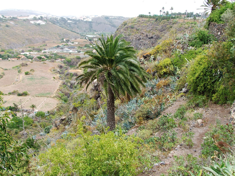
In terms of vegetation, copses of wild olive trees grow on the banks of the streambed and on the slopes, as well as exuberant groves of palm trees. Other species and the vegetable and fruit plantations we'll find on the way, together with the trail's finishing point, the "Viera y Clavijo" Botanic Garden (with an outstanding collection of flora endemic to the Canary Islands, in addition to flora from other bioclimatic regions in the world), make of this trail a botanic delight.
Finally, there are some ethnographic and archeological elements of interest along this itinerary. There are still some washing places to be seen, known as veleros, genuine examples of the age-old water culture of this area. Women were in charge of this work, and washing places often became a social meeting point for them. There are also some interesting archeological sites in the neighbourhood of the trail, like the Cuevas de La Angostura, in La Angostura, a complex of manmade caves dug into the volcanic tuff on the sunny hillside, with basins of varying size dug into the ground, and the Cuevas de Los Frailes, on the hillside of the La Caldereta del Lentiscal volcano, past the Puente de La Angostura bridge, although their state of preservation is rather poor given the fragility of the material they have been dug into.

Trail Map
(Click on the map to enlarge it)
Trail Profile
(Click on the map to enlarge it)
 Trail description
Stage 1: Puente de Las Meleguinas - Puente de La Angostura
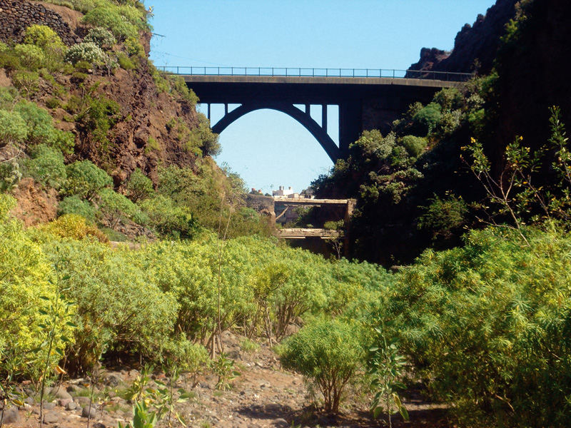
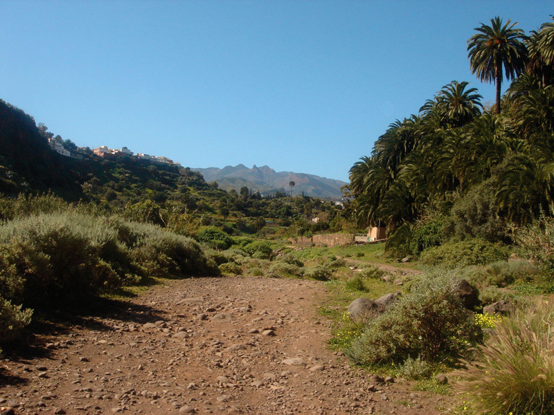 If we set off from Santa Brígida, we have to take the road in the direction of Los Olivos, and the turning to the left. About 1,6 kilometres on we'll come across the Puente de Las Meleguinas bridge; if coming from Las Palmas de Gran Canaria, we'll arrive at the bridge via the La Calzada road, driving across the Puente de La Angostura bridge -which is about 3 kilometres away from our starting point.
Getting down to the ravine bed is easy: we take the road to Pino Santo (signposted) and turn immediately to the right onto a dirt track that leads down to the bed of the ravine. Once we have got down there and crossed under the bridge we'll come to an information panel that describes the Protected Landscape of Pino Santo and Barranco Alonso.
We set off along the bed of the ravine, which at this stage is wide, flat and open, allowing us to enjoy the sight of the vegetation around us: wild olive trees, palm trees and spurges (Euphorbia regis-jubae) as well as the vegetable and fruit plantations which, especially in winter, are a delight to behold.
After about 15 minutes we'll come to the washing places. In Las Meleguinas a festivity is still held known as the Bajada al Velero (Descent to the washing place) and the villagers meet by the washing places and imitate the activity of the washerwomen amidst celebrations.
As we carry on we notice a variety of land uses around us: farmland, housing, even municipal sport facilities. Once past the football ground we take the turning to the right. We will come to a second complex of washing places, where there is a rest spot where we can stop for a moment, if we so wish.
We continue our descent and we come to a power tower near some spurges; ahead of us we can see the Montaña de La Caldereta del Lentiscal mountain, also known as Montaña de La Atalaya or Montaña de la Cueva de Los Frailes. We take the turning to the left, which brings us to yet another complex of washing places and another rest spot, across which we walk to abandon the dirt track and re-enter the bed of the ravine towards the Puente de La Angostura bridge.
Stage 2: Puente de La Angostura - Jardín Canario

This second stage of the itinerary poses greater difficulties. It runs along the boxed in ravine bed, with alluvial and colluvial material of varying size as well as rocky outcrops we'll have to get round. There is also the possibility of walking along the ravine bed bank, where the vegetation makes progress awkward but not impossible.
White weeping brooms (Retama raetam) grow abundantly here, and during their flowering season they splash the hillsides with their colour, exhaling a pleasant scent. The rest of the thermophilic vegetation is of a more xerix character, though they are generally replacement species. The most common are bitter spurges (Euphorbia obtusifolia), shrubby docks (Rumex lunaria) and buglosses (Echium decaisnei), among others.
We walk through the village of La Calzada, where we come across some sport facilities that we leave to our right, and we carry on downhill as far as a cluster of houses at which point we take a path that runs on top of a water pipe. After about 600 metres we come to Dragonal Bajo, where we join the main road that will bring us to the Jardín Canario, a Botanic Garden of great interest and definitely worth a visit, where our itinerary comes to an end.
It is the largest botanic garden in Spain, with a surface area of over 27 hectares. The Swedish botanist Eric R. Sventenius conceived the idea of creating a space where to gather the floral wealth of the Canary Islands, and in 1959 the Jardín Botánico Viera y Clavijo, its proper name, was opened to the public. At present, the collection includes flora from all the Canary Islands -except from the High Mountain areas- as well as from other Macaronesian regions and other parts in the world. The garden is structured into distinct areas, each of them with its own name: Plaza de las Palmeras (Palm trees square), Área de Pinar (Pine Grove zone), La Laurisilva (Laurel forest) or Jardín Macaronésico Ornamental (Ornamental Macaronesian garden), among others. There are also landmarks that beautify even further an already striking place, such as the Fuente de Los Sabios (Wise men fountain), the Puente de Madera ((Wooden bridge) or the Cueva del Viento (Wind cave).
The Garden is also a prestigious centre of research on the islands' flora, and works on the preservation of endangered vegetal species. Research work developed in the fields of palynology, cytogenetics, in vitro developmental biology, molecular biology, and so on is published in the Botanic Garden's own journal, Botánica Macaronésica. The Garden has also become a champion of environmental education, with its own environmental programme aimed at schools and other institutions and social groups.
It is open to the public every day, between 9 am and 6 pm.
The washing places in the Middle Guiniguada ravine
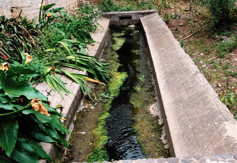
Hydraulic engineering is a significant part of the cultural heritage of the municipality of Villa de Santa Brígida, especially along the middle stretch of the Guiniguada ravine. On both sides of the bed of the ravine we'll find water distribution basins used to supply local farmers with irrigation water, irrigation ditches that run across bridges to overcome the height differences found along the bed of the ravine, water tanks and washing places, known as veleros in this area.
Water is a scarce resource in the Canary Islands, and local farmers have had to build a range of structures to collect, distribute and store it. A washing place or velero is a rectangular structure formed by the widening of an irrigation ditch near a settlement for the purpose of washing clothes. It is lined with special stones on which to scrub the clothes, and some of them have a roof to shield the women from the sun.
The velero was a meeting point for women, where they would exchange stories and gossip. Women would often bring their young children along, and would give them a bath while doing the washing.
The soap traditionally used was what was known as Swaston or Lagarto type soap, which was a large bar of soap that was cut into smaller pieces big enough for the day's washing. The main raw material for this soap was soda, which in the Canary Islands was obtained from the ashes of the barilla (salsola soda) and was then mixed with animal fats or oil. With the development of chemical soda, the use and trading of barilla-derived soda declined.After washing them, the clothes were hung in nearby areas to air and dry. Once dry they were collected in large washbowls and women and children returned home.
The origin of the name velero (velero in Spanish means sailing boat, and a velo is is a veil) not clear, and there are two theories about it. One claims it derives from sheets hung out to dry, which would resemble the sails of a boat; others believe that it refers to the sheet of water which, like a veil, flows over the bottom of washing place.
SOURCE: http://www.fedac.org
Erect prickly pear (Opuntia dillenii)
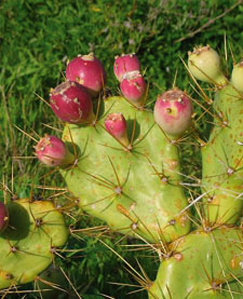
It originally came from America. It is an invasive xerophilous shrub that forms dense communities that often displace native species.
It belongs to the Cactaceae plant family, although cochineal insects do not feed on it, which means that it is of no use for the manufacturing of dyes. It is grown for its fruit. It can grow up to a metre in height. It has fleshy "pads" (actually, stems) and its areoles have a diameter of 7-10 mm, with 6-8 long spines and painful glochids. Its flowers are of a pale yellow colour, and its fruit, purple in colour, has the effect of turning urine red, and has been used to fight jaundice. At present it is often used to make fruit juice shakes mixed with other fruit such as pawpaw.
In Cuba wine has traditionally been made with its juice, and the mucilage found in its stem is used to manufacture paint.