


La Bodeguilla - La Atalaya
GENERAL DESCRIPTION. The trail goes from La Bodeguilla, in the municipality of Vega de San Mateo, to La Atalaya, in the municipality of Villa de Santa Brígida. The stretch of trail within the village of La Atalaya itself is of great ethnographic interest.
The trail runs mostly along tarmacked roads -formerly paths-, but the beauty of the landscape and the interest of the natural and cultural elements that we'll come across are a delight and worth the effort.
La Bodeguilla lies between the mountain of the same name and the Lomo de Los Silos ridge, along a narrow ridge that separates two ravines. The landscape is essentially agricultural in character, and the shrub and tree species to be seen are those derived from the effects of human use of the territory, such as chestnut, fig and almond trees, or reedbeds in areas of higher soil moisture, as well as replacement species that grow spontaneously in areas that are no longer farmed, like sorrels (Rumex lunaria), which are very widespread, and bitter spurges (Euphorbia obtusifolia).
As we walk down we'll notice the extensively farmed fertile lowlands of Vega de San Mateo and Villa de Santa Brígida (formerly known as Vega de Enmedio). This Middle Mountain Region landscape, integrated in the great basin of the Guiniguada ravine, reflects the agricultural character this area still preserves.
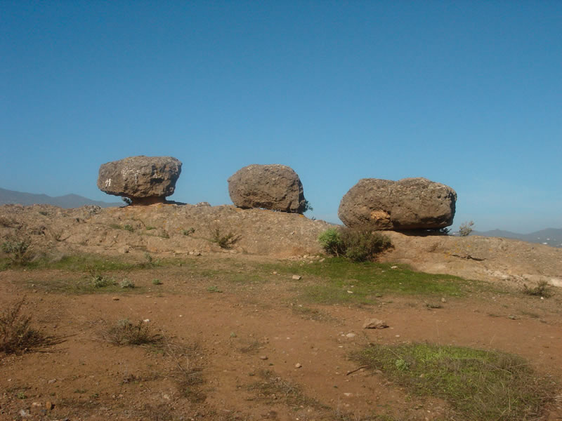
Along the trail we will also come across some peculiar geomorphological elements -such as for instance Roque Nublo agglomerates like Las Tres Piedras (The Three Stones), which have become a symbol of identity for the inhabitants of Santa Brígida and a scenic reference for walkers.
As we end the second stage of our trail we'll come to the adjacent villages of La Concepción and La Atalaya, both in the municipality of Santa Brígida. Farming terraces and hydraulic infrastructures combine with traditional style houses in La Concepción, although good road communications have favoured modern suburban developments that have been successfully integrated in the village's environment. La Atalaya has also managed to preserve its traditional character, and it is still possible to perceive in it the importance that pottery has had here for centuries.

Trail Map
(Click on the map to enlarge it)
Map Profile
(Click on the map to enlarge it)
 Trail description
Stage 1: La Bodeguilla - Cruz del Gamonal
 We start from the farmers' market in Vega de San Mateo. We walk down the street for about 360 metres until we get to a turning to the right towards La Bodeguilla, which is signposted.
La Bodeguilla is about two kilometres away from here, and we can get to it either on foot or by car, for our trail actually starts at La Bodeguilla, at a bus stop that lies next to a nursery school. We take a turning to the left, a concrete path that soon turns into a dirt path, that climbs up a gentle slope and skirts the base of Montaña de La Bodeguilla. 50 metres away from our starting point we walk past a traditional style house.
Throughout this stage of our trail and part of the following one -as far as Cueva de los Gatos-, we'll walk along a ridge that separates two slopess with very different landscapes. To the south the vegetation is made up of replacement shrubs, mainly Canary Island brooms (Teline microphylla), together with other tree species such as eucalypti, non-native pine trees -the striking result of reforestation programmes- and wild olive trees, which used to be the predominant species on this sunny hillside. To the north we have a view of the middle stretch of the basin of the Guiniguada ravine. The landscape in this case is fundamentally agricultural in character, with dispersed settlements.
The first stage of the trail comes to an end at Cruz del Gamonal, easily identifiable by the three crosses raised next to a water distribution basin, an old hydraulic infrastructure used to supply water to farmers and as a water trough. By now we will have walked 1,400 metres from La Bodeguilla or about 3,300 metres if we started off from Vega de San Mateo.
Stage 2: Cruz del Gamonal - La Atalaya
 From here on until La Atalaya the itinerary runs along tarmacked roads. We carry on from Cruz del Gamonal as far as Las Tres Piedras. The geological material on which we walk is volcanic breccia (Roque Nublo agglomerates), an example of which is the rocky outcrop known as El Gurugú; Montaña del Bermejal mountain is made of older material which was isolated by the surrounding volcanic breccia.
If we go to the scenic viewpoint that we'll find to our left we'll be able to enjoy an excellent panoramic view that goes from the island's high mountain region down to the city of Las Palmas de Gran Canaria. About 100 metres past this scenic viewpoint, by a narrow curve to the right, we'll find a dirt path that will bring us to Las Tres Piedras, a curious example of a process of differential erosion. From here we can go back to the tarmacked road or alternatively carry on along this dirt path which eventually rejoins the road. The second option saves you 500 metres of tarmac.
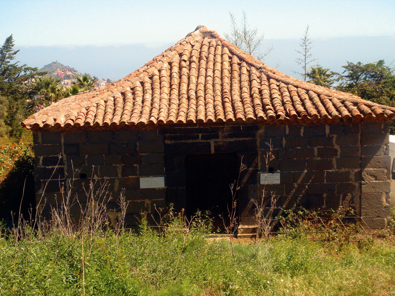
We soon get to the housing estate of La Concepción, where we'll find the chapel of the same name, which is a Historic Artistic Heritage site. From an architectural point of view it is a simple structure. The remaining central nave is in its original state; its walls are made of stone extracted from the quarry at La Atalaya, and the ceiling is mudéjar in style. There is a wooden pulpit and polychrome figures of Our lady of the Immaculate Conception and of Saint Francis of Paula. Victims of the cholera epidemic of 1851 were buried here -old tombstones dating from that time can be seen on the chapel's façade. The chapel is at present privately owned.
We carry on walking down the hill towards the village of La Atalaya. We take a street called El Estanco as far as a crossroads, where we take the turning to the right, which will bring us to the church of this village, long known for its pottery.
A tour of La Atalaya
Up until well into the 20th century the potters in La Atalaya supplied the whole of the island with a range of domestic items.
The potteries in the village are of great interest for basically two reasons: in the first place because they are housed in manmade cave dwelling-workshops dug into the soft volcanic tuff, which do not differ substantially from the cave dwellings similarly dug by the prehispanic inhabitants of this area; according to 18th century written records, at one stage up to two hundred cave-dwelling families worked in the local pottery industry. Secondly, because the rudimentary pottery techniques used by local potters provide a direct cultural link with the techniques used by the prehispanic inhabitants of the island, and thus possess an ethnographic dimension that goes beyond the work's aesthetic value. These two factors make of the potteries in La Atalaya a veritable treasure central to the island's cultural heritage.
We have two options when starting our tour of La Atalaya. We can either take La Picota street towards the northern side of the potters' quarter, or we can take the entrance to the southern side of the potters' quarter that we'll find opposite the church of San Pedro.
La Picota street takes us directly to the Centro Locero (Pottery Centre) of La Atalaya and to Panchito's pottery. The Centro Locero is a meeting point for all those who wish to preserve or to learn the pottery techniques the local potters have used since prehispanic times. Panchito was the doyen of La Atalaya's potters. His home and workshop have been turned into a House Museum that perfectly preserves the distribution, decoration and tools used in his workshop and home, including the clay, ravine sand and pebbles and ochre brought all the way from the High Mountain Region, -even the central patio with the plants and pets that he kept there.
We follow the cobbled path through the interior of the potters' quarter until we get to a place known as Lugar El Lomito. Here we turn right, in the direction of the kiln, we walk up some steps that bring us to a park and scenic viewpoint which offers splendid views of the Barranco de Las Goteras ravine and of the rural settlement known as La Culata.
We continue walking along the path, towards the cave-workshop of María Guerra (a.k.a. la Quemá, or "the burnt one"). Before we get there we'll come to the Horno Viejo (old kiln) to our left. Pottery kilns were traditionally used jointly by different families. Both the Horno Viejo, near Mariá Guerra's cave, and the Horno Nuevo (new kiln), in the patio of the Centro Locero, have been recently restored as part of the sustained effort to preserve the village's heritage.
The trail finishes with a visit to María Guerra's cave-workshop. This allows us to see at first hand a traditional manmade cave dwelling and workshop, which has been dug into the soft tuff very much like the prehispanic inhabitants of the island did. We'll also have the chance to look at the ceramic ware, and see that it is essentially functional in design, made with the use of techniques that date from neolithic times, and adapted to the domestic needs of rural families, although nowadays the range has expanded to increase its appeal among tourists.
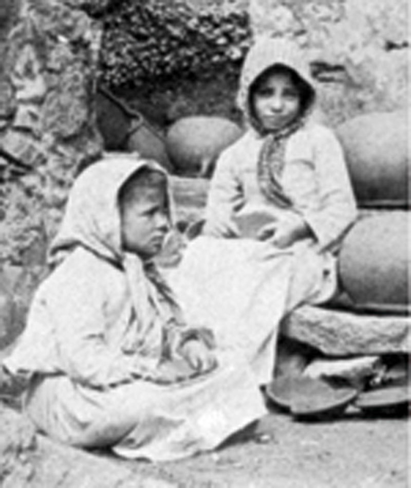
The frequent presence of daughters, granddaughters and great-granddaughters along our trail, sitting on a rock outside their homes, will enrich our itinerary, since their conversation and chatter are the true transmitters of La Atalaya's identity. María and her sister Juana run the last active pottery at the north end of the potters' quarter. They wait expectantly for visitors, and remember how in their youth, in the 1940s, they'd see them coming on buses across the Puente de Las Goteras bridge, and how they'd rush to get the workshop and ceramic ware ready. Once the visitors arrived the two girls would ask them for un peni, un peni! (a penny a penny!), to see if they'd give them some money.
With help from the younger members of the family they store the clay with which they make an ever decreasing number of pieces which they then take to craft fairs. Large vessels, jars for storing gofio, smaller pots for storing nuts and grain and roasting trays are, among others, some of the pieces they shape and then take to the Horno Viejo, the old kiln, to bake.
Alfarería tradicional: la familia alfarera
Pottery is one of the oldest human activities. It is related to the discovery of fire and to the need to to store the products gathered by primitive men or, in the case of the Canary Islands, the aboriginal population. The prehispanic technique made use of no potter's wheel, everything was done by hand. On Gran Canaria, where ceramic ware is known as loza, there are three places that enjoy a great reputation for their pottery: La Atalaya de Santa Brígida, Hoya Pineda in Gáldar and Lugarejos in Artenara. The three of them have access to good clay, ochre, ravine sand and abundant firewood to feed the kilns.
Potteries used to be set up in manmade caves dug into soft volcanic tuff or Roque Nublo agglomerates. The workshop, usually owned by the potter herself -it was mostly a woman's trade-, was normally set up in caves adjacent or close to the potter's dwelling.
If we have a walk round the potters' quarter after about 4 pm -which somehow resembles a Moroccan souk-, we'll be able to enjoy the chatter of women -potters' daughters, granddaughters and great-granddaughters- sitting on rocks (known as toscas) outside their cave dwellings reminiscing about the day to day history of a village quarter that found in pottery the means to escape poverty. These are now old ladies, for most of whom pottery now belongs to the past, people like María and Juana Guerra, Carmen, Juana Vega's granddaughter, Teodoro Rivero, Carmen Dávila, Juana Narcisa's granddaughter, and Faustinito Santana, Cho Dolores Benítez son-in-law, who help us understand where this quarter -which was once a point of reference for the first scientific tourists to the island of Gran Canaria- has come from.
Rescuing traditions: the Traída del Barro ("the fetching of clay")

Every year, during the festivities in honour of Saint Peter of La Atalaya, the village inhabitants (known as talayeros) walk up to La Concepción and rememorate the days when potters went there to fetch clay that they would later store during the winter in their workshops.
Participants first meet at 1.30 pm and have something to eat at La Picota; a couple of hours later they walk up to La Concepción to the sound of a music band, which helps to forget the early afternoon heat. Many neighbours come to watch, even if they will not participate in the coming revelry. At about 4 pm, the participants stand in a circle, water is poured and revellers roll around in the mud until well into the evening, when the breeze of the trade winds announces that the time has come to go back down to the village and to a good shower.