


San Mateo - Valsequillo
GENERAL DESCRIPTION. This itinerary runs through two municipalities: Vega de San Mateo and Valsequillo. As the trail progresses we'll find notable changes in the surrounding landscape, as we'll go from the windward side of the Middle Mountain region of Gran Canaria to an area of transition to the leeward side of the island.
As we enter the leeward side of Gran Canaria we'll notice the climate becoming more arid, which also happens as we descend towards the coast. This explains why rainfall rates are lower in the basins of Tenteniguada and Valsequillo than in Vega de San Mateo. Temperatures in general are also higher in the Valsequillo basin than in the Guiniguada basin.
Geological characteristics are similar in both municipalities. In the higher areas the material is essentially agglomerates and lava flows belonging to the Roque Nublo and Pre-Roque Nublo cycles. In the lower areas it is mainly lava material of basaltic series II and III (Fuster et al, 1968).
The characteristic vegetation of the Middle Mountain region is both the laurel forest and the fayal-brezal undergrowth/shrubland; in High Mountain areas it is mainly pine forests and broom and flatpod shrubs. Finally, in coastal areas what predominates is the thermophilic forest (wild olive trees, lentiscs and mastic trees). All these strata of vegetation have been heavily altered by human intervention.
Human use of the territory includes agriculture and livestock farming, both in Vega de San Mateo, as we have already seen (see routes 4 and 5), and inValsequillo and El Helechal. In Valsequillo there are many goat farms, with a high production of industrial cheese. There are also important capitalized plantations, mainly of strawberries and vegetables. El Helechal is an area specialized in open air ornamental plant nurseries (carnations, lilies, houseleeks, etc.) and plantations of leaf vegetables such as lettuces and Swiss chards.
The production of almonds in Valsequillo, as in Tejeda, is important. The festival of the almond tree in bloom is also held here, in the month of January. Almond trees make up for a colourful and unique landscape.
Residential developments have spread throughout the headwaters and the middle areas of this municipality, mostly in the shape of detached, terraced and holiday homes.
Both municipalities are well communicated, and the roads connecting them are kept in good condition.
It is easier to follow the trail in the Vega de San Mateo-Valsequillo direction, as most slopes will be downwards and thus less tiring.


 Trail description
Stage 1: San Mateo - El Montañón
 The path starts at Vega de San Mateo, in the hamlet of La Higuera, right opposite the building currently shared by the San Mateo Town Council's Social Services department and the Association of Middle Mountain Region Municipalities of Gran Canaria. We walk down El Cantillo street, past an electricity pylon and a few houses, until we get to a first fork, where we turn left. We will soon come to a bridge, walk across it and take the next turning to the right.
We carry on along this main road, ignoring any turnings we come across. After about 20 minutes we come to the end of the road and and the beginning of a path. This path will take us to a tarmacked road which will, in turn, bring us to a hill ridge, Lomo del Montañón, which lies in an eastern direction (90º).
From this spot we'll enjoy wonderful views of the village and of the fertile lowlands of the municipality we are leaving behind, Vega de San Mateo. We'll also see an abundance of brooms, false brooms, spurges, brambles and Arabian peas; most of these species are used as livestock forage.
Stage 2: El Montañón - El Helechal
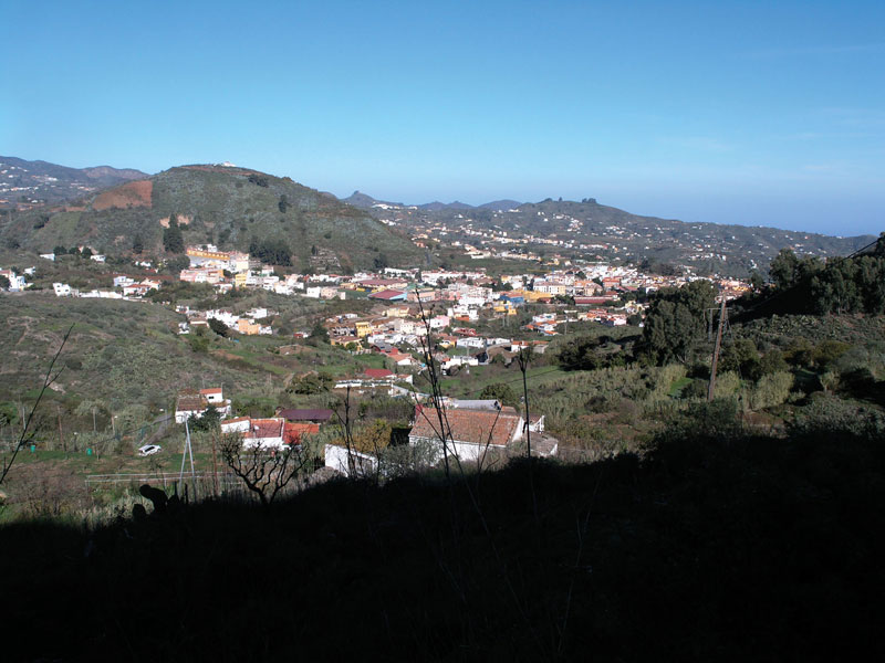
 If we look ahead of us we'll see the valley of Valsequillo and the Barranco de San Miguel ravine. We cross over to the left when an isolated house comes into view. We carry on along the Lomo del Montañón ridge and will eventually come to a sign that tells us we have arrived at El Montañón. We take the turning right, towards Valsequillo and walk along a tarmacked road. To the left we can see the city of Las Palmas de Gran Canaria in the distance and, a bit closer to us, the villages of Villa de Santa Brígida and El Monte Lentiscal; to the right lie the villages of Valsequillo, Tenteniguada and El Helechal-.
After walking past a high tension pylon, we arrive at a hamlet called Degollada de Los Cardos. A gravel track starts here, which leads to a former one-room school. About 40 or 50 metres past this school we'll come across the path that runs down towards Vueltas del Helechal, which we take. The path starts by two water balsas de agua that lie on the bottom of the ravine, at a place known as Llano del Helechal, and comes to an end once it gets to the first few houses of this village, where we will once again take a dirt track.
Stage 3: El Helechal - Valsequillo
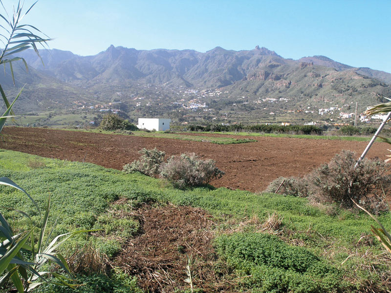 The scenic viewpoint at El Helechal, where we are heading to, comes quickly within view. To get to it we need to walk along the El Helechal tarmacked road, as far as a sign that reads "prohibido estacionar" (No parking).
We turn left and soon come to an electricity pylon. We are now very close to the base of the cone of El Helechal. Although going up it is not included in our trail, it does offer nice views over the basin that stretches from Tenteniguada to Telde. We must watch out for the path -it is easy to miss it- that we have to retake to continue on our walk. It lies next to a house at the start of the mountain side, past the road safety barrier. We'll find two paths next to each other; we should take the one closest to the telephone post. Following this path we'll walk past the shooting field of La Caldereta, where we will see fossil and clay soil areas of great value to potters.
The scenic viewpoint at El Helechal, where we are heading to, comes quickly within view. To get to it we need to walk along the El Helechal tarmacked road, as far as a sign that reads "prohibido estacionar" (No parking).
We turn left and soon come to an electricity pylon. We are now very close to the base of the cone of El Helechal. Although going up it is not included in our trail, it does offer nice views over the basin that stretches from Tenteniguada to Telde. We must watch out for the path -it is easy to miss it- that we have to retake to continue on our walk. It lies next to a house at the start of the mountain side, past the road safety barrier. We'll find two paths next to each other; we should take the one closest to the telephone post. Following this path we'll walk past the shooting field of La Caldereta, where we will see fossil and clay soil areas of great value to potters.
From the road we can see, below us, a covered water tank. This road will bring us directly to the centre of the village of Valsequillo. We walk through the area known as Majuelo until we get to La Orilla Street. We carry on down this street and when we get to a traffic sign that indicates we are at point 0 kilometres on the GC-812 road, we take Sol Street, which will bring us to León y Castillo Street, an urban road that leads to the San Miguel Church Square.
It will have taken us three hours to cover 6 kilometres, during which we will have enjoyed splendid views of Valsequillo, Tenteniguada and Barranco de San Miguel to the east, and of San Mateo and part of the Guiniguada ravine to the north of the island.
Livestock farming
The point of livestock farming is the production of animals in order to obtain meat and other derived products such as milk, eggs, leather and wool.
There are two basic types of livestock farming, known as intensive and extensive livestock farming. The former is the result of a capitalist rationale and the application to this activity of multiple profit-seeking techniques. Intensive livestock farming developed in Spain during the 1960s, and its underlying principles are the seeking of the highest profit over the shortest period of time, concentrating the means of production and the mechanization and rationalization of processes to constantly increase productivity. Aviculture is an example of intensive livestock farming.
Extensive livestock farming, on the other hand, is characterized by forming part of a natural ecosystem modified by human intervention, in other words, it generates an agroecosystem whose aim is to make a lasting use of the territory, subject to natural cycles. It tends to preserve a wide-ranging relation with the vegetal production of the countryside of which it forms part. In other words, it is a form of sustainable development. An example of extensive livestock farming are free-range cows.
In the past, livestock farming enjoyed much greater importance, since at present many of the livestock products we consume come from outside the islands, as EU legislation (Régimen Específico de Autoabastecimiento, or Specific Supply Regime) allows the importing of meat and cheese at very competitive prices. It is worth highlighting, however, that the quality of our livestock products is often superior, cheese being a case in point. The cheese produced in Gran Canaria in general, but especially in the Middle Mountain Region municipalities of Vega de San Mateo, Valsequillo, Tejeda and Villa de Santa Brígida are outstanding and very much sought after. There is a high rate of per capita consumption of local cheese in Gran Canaria, which enables our livestock farmers to compete in European Union markets.
The Canarian knife o naife
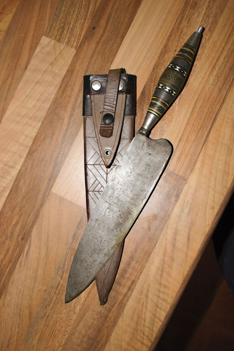
The Canarian knife, also known as naife -a term derived from the English word knife- is widely used in the rural areas of Gran Canaria. It is used for cutting the stem of banana clusters, cutting forage for animals, cutting cheese, for sharpening wooden items, and so on. It is, basically, a multifunctional tool.
Their most characteristic feature are their handles; they are really what knife-makers craft, for the blades are made by smiths or blade makers.
To make the handle or cabo, an inlaying technique is used, which involves laying small pieces of ivory, mother-of-pearl,bone, nickel silver, nickel, copper, aluminium, brass, gold and silver between the wood and the metal, creating unique colourful patterns.
It is exclusively a man's job, and knives often pass from father to son.
The tools required to craft the handles are the following: files, polisher, hammers, saws, sharpening machines, rasps, a table-top lathe, pliers, shears, drills, a bow saw, a compass and a rolling mill.
The most common decorative motifs are known as: the cruzada, the derecha, the espinilla, the rooster's eye, the spike and the crosses.
(SOURCE: Murcia Suárez M. http://www.fedac.org)