


Las Lagunetas - Utiaca
GENERAL DESCRIPTION. This is a very humid area, with low temperatures in winter (8º-10º C) and high temperatures in summer, about 30º C on average -although thermometers may reach up to 35ºC on occasions. Thus moist laurel forest species -and pine forests at higher altitudes- tend to make up the lush vegetation of this area.
The landscape is characterized by steep slopes. Ever since the days that followed the Spanish conquest, terraces have been built on the mountain sides for the development of dry farming. Local agriculture is based on traditional techniques such as crop rotation, the most common being alternate year rotation and biennial and triennial rotations, and multiple cropping, when two or more crops are grown in the same field within a given year. The aim of these techniques is to avoid soil exhaustion and the preservation of its fertility while at the same time producing the largest and most varied range of products possible. Agricultural production is significant in Utiaca -fruit, vegetables, tubers and legumes- and a great deal of the traditional character and values of rural areas in Gran Canaria can still be experienced here.
Bartering, or the exchange of products without the need for money, has traditionally been a common practice in this area.
Handiwork is mostly wickerwork, embroidery and loom work. Artisans have been mostly the farmers themselves, who have crafted the tools necessary for their work and for other activities.
Water from both springs and infiltration galleries is plentiful, and it can be seen running all throughout the year down the Barranco de La Mina ravine.
Local architecture has to a large extent preserved traditional features, and there are still many drystone houses in this area with Canarian gable tiled roofs.


 Trail description
Stage 1: Las Lagunetas – Water distribution station
 The trail's starting point is in the church square in Las Lagunetas. We walk down some steps opposite the church façade that bring us to a tarmacked road. We walk towards the northeast, towards the bottom of the Barranco de La Mina ravine, in the direction of La Yedra, and after about 200 metres we come to a curve where the road ends and a dirt track starts.
We walk down this track to the bottom of the ravine. The track runs amidst abundant vegetation, both native and introduced. Dry farming is widespread, and along the trail we will come across some sheds with sheep and goats, and occasionally with cows as well.
After about two kilometres we'll come to a bridge that lies across the ravine, by which we'll find a water distribution station where part of the ravine's water is piped to supply both the local population and the population in coastal areas. The bridge is relatively modern; close to it there is another stone bridge that dates from the 19th century and which is no longer in use.
Water can be seen running down the ravine, with willows (Salix canariensis) growing on its banks.
Stage 2: Water station - La Yedra
As we walk past the water station we enter a narrow dirt path that seems to have been cobbled over certain stretches at some stage. We must watch out for a turning to the right, towards the bottom of the ravine, about 200 metres past the water distribution station, which lies hidden in the shrubland.
Walking down this path we'll come to a house with a porch, and further on to some steps that lead down to a concrete path. It is rather steep, so we should walk slowly and carefully. Once we get to the bottom of the ravine we'll find a track that runs parallel to the streambed. The track surface alternates between tarmack and concrete. There are several turnings that lead to private farms and properties, but we should ignore them all and walk on in the direction of La Yedra.
Stage 3: La Yedra - Utiaca
This final stretch of trail runs along a dirt track with a very low gradient. We'll come to a dirt car park first and then to a bar-restaurant. Near this restaurant, in Utiaca, we'll find a lavadero that makes use of the water that runs down the ravine.
Utiaca
This district lies within the area of influence of the Barranco de La Mina ravine. The geomorphological make up of this area is rather peculiar. The Guiniguada ravine became blocked during the Quaternary; the water that ran along it was consequently dammed and a lagoon was formed, which explains the accumulation of soil in this area.
During the Middle Quaternary fluvial erosion opened up the ravine again, widening the area immediately below Utiaca. Indeed, there is in this area a significant widening of the Barranco de La Mina ravine, forming this broad interior valley that is known as the basin of Vega de San Mateo. The combination of rich soils and abundant rainfalls facilitates agricultural development, favouring intense productivity and produce of excellent quality. A large part of the products sold at the Sunday market in San Mateo come from this area, especially potatoes, cereals (mainly corn) a variety of fruit (plums, peaches, apples and pears) and vegetables (onions, carrots, cabbages, tomatoes, pumpkins and courgettes).
The current population is of 1,202 inhabitants, according to the 2006 census, and it is demographically the second settlement in importance after the village of San Mateo itself (3,252 inhabitants in 2006). It is one of the areas in the Middle Mountain Region that is actually experiencing a demographic resurgence, mostly due to its agricultural importance.
Cabinet making and woodwork(1)
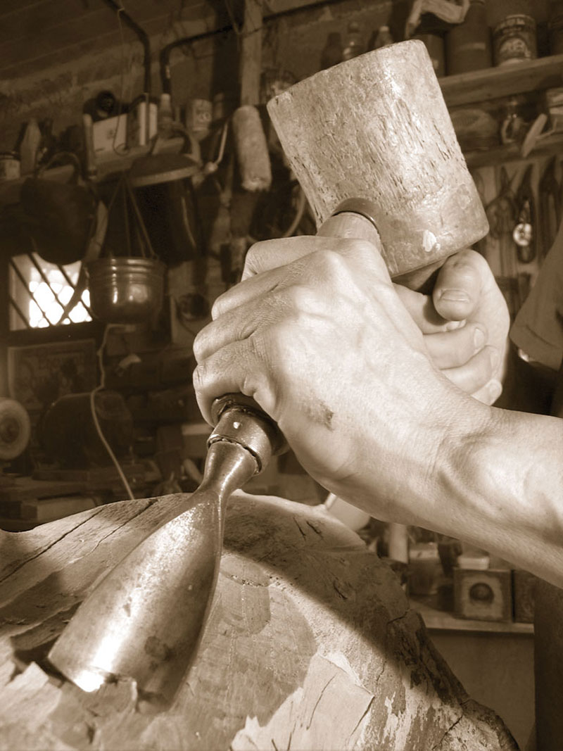
Woodwork and cabinet making are very similar trades; the main difference lies perhaps in the fact that in the first case all kinds of woods are used, whereas cabinet makers work essentially with hardwoods: mahogany, African walnut, African mahogany, sipo, Swedish and Finnish pine wood, oak, beech, heartwood and mulberry tree wood.
The finishing of the pieces also sets them apart, cabinet making being much more sophisticated, with the use of techniques such as woodturning, inlaying and carving . They tend to be high quality products. Cabinet makers were commonly hired to make roofs, tongue-and-groove panelling, eaves and doors.
The main tools of the trade, both in the case of carpentry and cabinet making, were, among many others, the following: the saw, the lathe, sanpaper, the hammer, gouges, chisels, burins, carpenter's glue, lacquer, varnish, wax, la cera, cross-cut chisels and planes.
Carpentry developed in the Canary Islands from the 17th century on, although the trade had been known before then -it was usually the farmers themselves who crafted their own wooden tools. The most commonly used woods are: pine wood, Phoenician juniper, cedar wood, eucalyptus, walnut and chestnut tree wood, -all of them abundant on the island, even though some of them, like the last three listed, are not native species. After the intense deforestation the island suffered from the 16th century on, wood had to be imported, especially from America, Africa -hardwoods mainly- and Europe.
The carpenter's main tools are: the handsaw, the adze, the axe, the saw, the knife, shears, cross-cut chisels, rasps, gouges, burins, chisels, different sized mallets, the hammer, carpenter's glue, varnish, nails, studs, the table-top lathe, the drawknife, and so on.
(1) Information on cabinet making and carpentry has been gathered from the following bibliography:
AGUILÓ ALONSO, M.P., (1993): El mueble en España en los siglos XVI y XVII. Consejo Superior de Investigaciones Científicas. Ed. Antoquaria S.A., Madrid.
PEY ESTANY, S.,(1982): Ebanistería y Tapizado, Enciclopedia de CEAC, Barcelona.
V.V.A.A., (1995): El Hombre y la Madera, Ed. Integral, 2ª Edición, Barcelona.
ESTÉVEZ GARCÍA, S. (1978): Guía práctica del Carpintero, Sintes, Barcelona.
FERNÁNDEZ DE PAZ, E., (1991): Carpintería de Ribera, Junta de Andalucía, Sevilla.
V.V.A.A., (1995): El Hombre y la Madera, Ed. Integral, 2ª Edición, Barcelona.