


Caldera de Los Marteles - Tenteniguada
GENERAL DESCRIPTION. The Los Alfaques trail is special due to its peculiar values, both scenic and ethnographic. This is one of the most beautiful trails between the High Mountain Region and Tenteniguada; it offers stunning views from its higher stretches and from one of the best scenic viewpoints on the island, El Espigón. In fact, on clear days, the trail offers unequalled panoramic views of the Caldera de Los Marteles and Caldera de Tenteniguada, and of a large part of the northeastern coast of Gran Canaria.
The trail traverses terrain of unique characteristics. It starts from the northern end of one of the most impressive volcanic structures to be found on the island's central High Mountain Region, the Caldera de Los Marteles. It is a large crater of phreatomagmatic origin dating from the most recent eruptive cycle in the island's process of geological formation. The caldera was the result of particularly violent eruptions intensified by the fact that the volcano's magma came into contact with water from the aquifer.
The trail runs along one of the escarpments on the eastern edge of a second basin, the Caldera de Tenteniguada, along the interfluve that divides the Barranco de Los Cernícalos and the Barranco de Los Mocanes ravines to the east and the Barranco de La Capellanía ravine to the west.
This semicircular depression, open to the northeast, underwent a long erosive process that brought its lithologic structure to the surface; along the trail we'll see material from different geological periods, although there is a predominance of Roque Nublo cycle lavas and basaltic pyroclasts, together with other more recent material.
Phonolites are also to be seen in the large freestanding volcanic structures that crown the Caldera de Tenteniguada, like Roque Grande, Roque del Pino or Roque Saucillo, whose physico-chemical properties made them more resistant to erosive processes. In the lower stretches of the trail we'll come across sedimentary material, mainly colluvia, overlying more recent flows. In short, this geomorphological wealth -together with its scenic and floral values- has been acknowledged and protected with the inclusion of this area in the Special Nature Reserve of Los Marteles.
 The peculiar relief of this area also conditions its climatic characteristics. Its general orientation towards the northeast, and its height above sea level -between 800 and 1,500 metres- expose it to the influence of the trade winds, especially in the High Mountain Region, which means that humidity rates are high and that the appearance of the sea of clouds phenomenon is frequent.
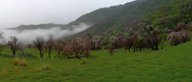
The final stretch of the trail runs on more level terrain, which together with sedimentary deposits has given rise to a fertile valley with a long history of agricultural use. The population is dispersed in rural nuclei linked to agricultural activities. Our trail, for instance, was not only the means of communication between Tirajana and the rest of the island via the High Mountain region, but was also used for the seasonal migration of cattle. Human use of the territory has also modified the distribution of the natural vegetation, which has been confined to the upper areas of this space, where there is a predominance of pine forests (Pinus canariensis). Brooms (Teline microphyla) grow along practically the whole length of the trail, and there is also a significant presence of other endemic species, such as sorrels (Rumex lunaria) and Canary Island alisons (Lobularia canariensis).

Trail Map
(Click on the map to enlarge it)
Trail Profile
(Click on the map to enlarge it)
 Trail description
Stage 1: Caldera de Los Marteles - Degollada de Los Cardos
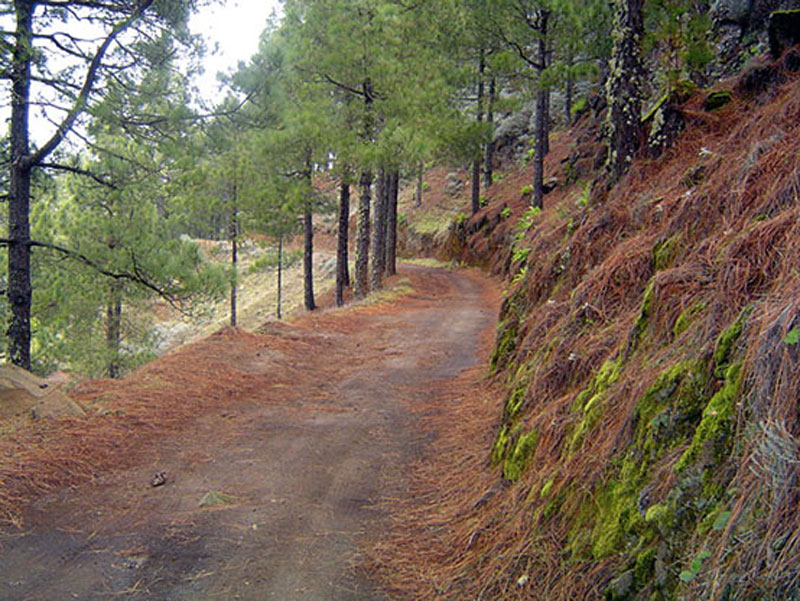
 We take the 18-3 road that goes from Telde to Los Pechos via Cazadores, as far as the Caldera de Los Marteles. Our starting point is a track that we'll find on the southern end of the caldera. It runs towards the east through a pine forest with an undergrowth made up of brooms and Canary Island sages (Salvia canariensis).
About 30 metres down the track we'll see a rocky outcrop to the right, where we'll notice several overlying lava flows colonized by aeonia (Aeonium simsii) and giant sow thistles (Sonchus acaulis). Shortly after crossing a ravine bed, visible to the right of our path, we'll come to a crossroads where we turn left. We carry on past a pigsty. From here on the vegetation becomes sparser, we leave the pine forest behind and the shrub forest becomes less dense. If we look towards the southeast we'll have a good view of the head of the Barranco de Los Cernícalos ravine, and of the abandoned farming terraces on its slopes. We continue down this gentle slope to the end of the hill ridge, where the path turns towards the southeast(1), only to change directions again further on, towards the northeast. An impressive dyke cuts across the path along this stretch of trail, at an altitude of approximately 1,360 metres above sea level.
Once we have gone past the dyke we change directions again at a narrow curve to the right. In a south-southeast direction we border the head of the Barranco de Los Mocanes ravine, and come to the end of this stage just before we get to a house that we'll see ahead of us, on the right-hand side.
(1) We should not be tempted to leave our track and take the shortcut that we'll find when our track starts veering to the right, towards the
southeast. It is indeed a shortcut that runs down to Morro de la Aguililla, but its surface is in a poor state and it has been taken over by shrubs that make it difficult to traverse. What we do recommend is stopping at this point to enjoy the exceptional views of Roque Grande and the basin of the Barranco de La Capellanía ravine, both towards the northwest.
Stage 2: Degollada de Los Cardos - La Mesa
 Before reaching that house we take a turning to the left where a path sets off in a southeastern direction. The path runs down the eastern slope of Degollada de Los Cardos towards La Mesa, also known as El Espigón. We carry on through a shrub forest, walking along an initial flat stretch of trail, followed by a steep slope, followed by another flat stretch and finally a gentle slope. An abandoned severely deteriorated shed to the right of the path reminds us of the importance livestock farming used to have throughout this area. We continue walking up and down gentle slopes through the shrub forest, where we'll notice an increasingly more widespread presence of bitter spurges. To our left we'll see an old animal enclosure made from stone.
If we look towards the northwest, we'll have splendid views of the High Mountain Region and of the settlement of El Rincón, on the slope of the Caldera de Tenteniguada. Towards the end of this stage in our itinerary, before we arrive at La Mesa, there are some cobbled stretches of trail which are interesting from an ethnographic point of view.
Stage 3: La Mesa - Tenteniguada
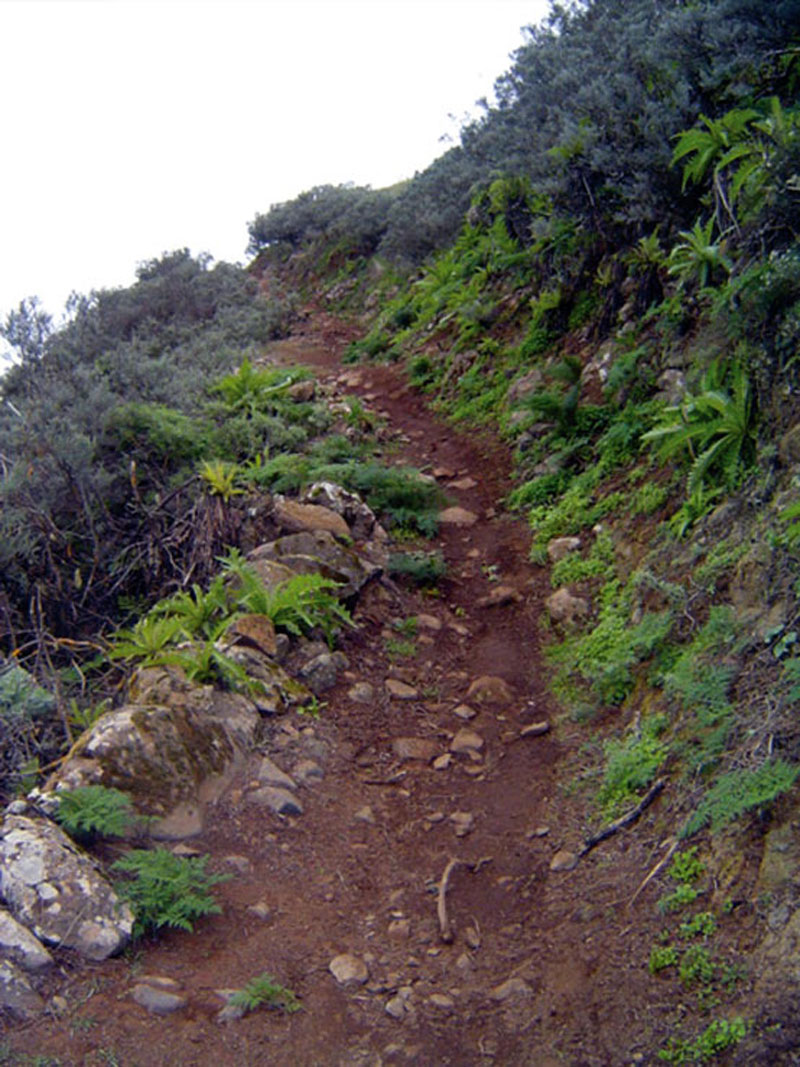
 This stage starts once we arrive at La Mesa -an easily identifiable shelf on the interfluve where the track widens and is covered by short pasture. We could stop here to enjoy the view and have a rest, for what lies ahead is the hardest stretch of the trail. We start our long descent along the Lomo de Los Alfaques hill ridge by a group of century plants (Agave americana) that lie to the left of the pine forest. Although it might initially seem easy enough, the steep slope and its slippery surface make the descent difficult at stretches.
The path twists and turns interminably all the way down, but it is important to resist the temptation to take shortcuts down the slope, for they are even steeper and increase the danger that we might slip and hurt ourselves. It is worth taking our time, walking slowly and enjoying the panoramic views of the Caldera de Tenteniguada and of the east coast of the island, as well as the vegetation that grows to both sides of the path -mainly brooms, but as we we walk down we also start to see spurges and giant sow thistles again and, for the first time since we started the trail, some sorrels and Canary Island alisons.
The slope gradually eases off, the first few houses appear and the dirt track comes to an end. we take a tarmacked road right next to a well with a little cavity at its base where there are still some tools associated with water extraction. We leave the well behind and carry on towards the east, in the direction of the cemetery, where our trail comes to an end. To get to the village of Tenteniguada we continue walking along the tarmacked road until we come to the main road (C-814 Telde-San Mateo) that will bring us to the centre of the village.
Canary Island Broom (Teline microphylla)
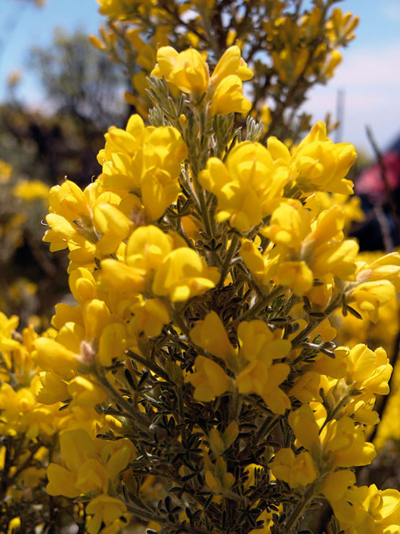
It is a leguminous shrub, the most widespread of all brooms in Gran Canaria, and grows in mountainous and degraded areas, which it quickly colonizes, in the centre and south of the island, between 250 and 1,900 metres above sea level. The Canary Island broom is endemic to Gran Canaria, although it does also grow on other islands such as Tenerife and La Palma. It is densely ramified and can reach a height of over a metre. It differs from other Fabaceae in that it is a tall shrub with trifoliate leaves, with yellow flowers of about a centimetre in size arranged in short axillary clusters, with a short period of inflorescence that goes from the end of May to the beginning of June. Its fruit is a densely tomentose oblong legume. Conditioned by thermal stress, its shape is semispherical and padded-like.
Throughout this itineray we'll find it together with other species that are also characteristic of this area, like the false broom (Chamaecytisus proliferus), the giant sow thistle (Sonchus acaulis) or the Canary Island sage (Salvia canariensis).
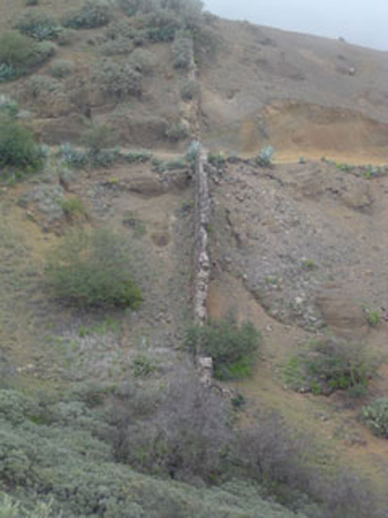
Volcanic dykes
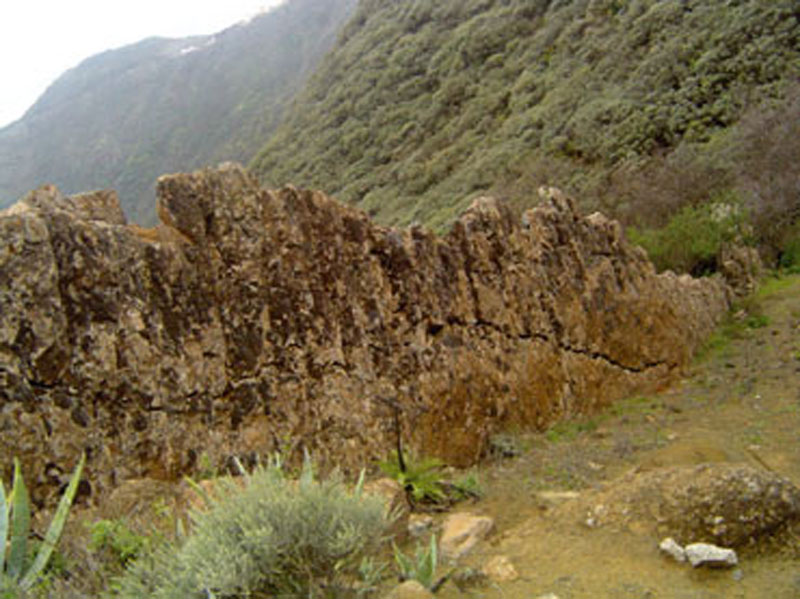
Dykes are emission conduits of fissural eruptions. The great pressure that molten rocks exercise on their ascent causes the opening of these vents through which magma enters volcanic edifices. Before this molten material reaches the surface and becomes lava, it cools down and undergoes a very slow process of solidification because the substratum on which it is boxed in transmits heat very slowly. That's why dykes are made up of very consolidated, compacted masses of intrusive rocks, whose mineral crystals are large enough to be identified with the naked eye.
When erosive processes bring them to the surface (exhumation dykes), geomorphological differences are lithologically determined, in other words, they depend on the greater or lesser viscosity of the original material. Materials of greater viscosity -salic magma- open up larger fissures and because of their greater resistance are also larger and wider than dykes whose original material was less viscous -basaltic magma-, which seldom reach a thickness of more than 5 metres since they do not need to open up such large fissures to reach the surface. The length of exhumation dykes vary, but some resemble manmade walls stretching out across the landscape.